The global agricultural sector is currently undergoing a profound transformation as traditional farming practices, once characterized by heavy manual labor and broad-scale mechanical intervention, are being augmented by sophisticated aerospace technology. At the forefront of this movement is the Unmanned Aerial Vehicle (UAV), commonly known as a drone, which has evolved from a niche hobbyist tool into a critical component of precision agriculture. This shift represents more than just a change in equipment; it signifies a move toward data-driven decision-making that optimizes resource allocation, increases yields, and minimizes environmental impact. As the global population continues to rise, the pressure on food systems has intensified, prompting a rapid acceleration in the adoption of drone technology to bridge the gap between traditional resource constraints and the growing demand for food security.
The transition from conventional methods to drone-assisted farming has followed a clear chronological trajectory over the last decade. In the early 2010s, drone use in agriculture was largely limited to experimental mapping by research institutions. However, the miniaturization of sensors and the improvement of battery technology around 2015 allowed for the development of specialized agricultural platforms. By 2020, the integration of Artificial Intelligence (AI) and Machine Learning (ML) enabled these machines to not only capture data but also analyze it in real-time. Today, the agricultural drone market is no longer a peripheral industry; market analysts estimate the sector will reach a valuation of approximately $6 billion by 2030, growing at a compound annual growth rate (CAGR) of over 20%.
The Multi-Faceted Utility of Agricultural Drones
The primary value proposition of drones in agriculture lies in their versatility. Unlike traditional tractors or manned aircraft, drones offer a "middle-ground" perspective that combines high-resolution detail with broad-scale coverage. This utility is generally categorized into three core functions: advanced aerial surveillance, precision application, and physiological plant analysis.
Advanced Aerial Surveillance and Mapping
Traditional land surveying is a time-consuming and labor-intensive process, often requiring farmers to traverse hundreds of hectares on foot or in light vehicles. Drones equipped with high-definition cameras and Real-Time Kinematic (RTK) GPS systems can map an entire farm in a fraction of the time. These maps provide centimeter-level accuracy, allowing farmers to identify topographical variations, drainage issues, and soil erosion patterns. By utilizing photogrammetry software, raw images are stitched together to create 3D digital twins of the landscape, providing a foundational layer of data for all subsequent farming operations.
Precision Application of Inputs
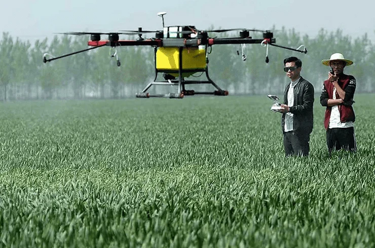
One of the most significant shifts in drone technology is the move from "sensing" to "acting." Spraying drones, equipped with large tanks and specialized nozzles, are now capable of delivering fertilizers, herbicides, and pesticides with surgical precision. Unlike traditional crop dusters or tractor-mounted sprayers, drones can fly just meters above the crop canopy. This proximity reduces "drift"—the unintended movement of chemicals to neighboring fields or water sources—by up to 30-50%. Furthermore, drones can perform variable rate application (VRA), where they only spray specific areas that require treatment rather than blanketing the entire field. This not only saves on chemical costs but also protects the local ecosystem from over-exposure to synthetic substances.
Physiological Health Monitoring via Multispectral Imaging
Beyond what the human eye can see, drones utilize multispectral and hyperspectral sensors to monitor plant health. These sensors capture light reflectance across various wavelengths, including near-infrared (NIR). By calculating the Normalized Difference Vegetation Index (NDVI), agronomists can determine the chlorophyll levels in plants. A decrease in NIR reflectance often indicates plant stress long before visible signs, such as yellowing leaves, appear. This early warning system allows for proactive intervention against pests, diseases, or nutrient deficiencies, effectively preventing large-scale crop failure.
Economic Data and Operational Efficiency
The adoption of drone technology is increasingly driven by hard economic data. Comparative studies between traditional labor and drone-assisted operations reveal stark differences in efficiency. For instance, in the application of pesticides, a manual laborer might cover one to two hectares per day in challenging terrain. In contrast, a modern agricultural drone can treat up to 10 to 15 hectares per hour. This represents a massive increase in productivity, particularly in regions facing labor shortages or aging farmer populations.
Supporting data from the Food and Agriculture Organization (FAO) suggests that precision agriculture, powered by UAVs, can reduce water consumption by up to 25% and chemical use by nearly 40%. For large-scale commercial operations, the return on investment (ROI) for a drone system can often be realized within a single growing season through saved input costs and increased harvest quality. Even for smaller cooperatives, the emergence of "Drone-as-a-Service" (DaaS) models has lowered the barrier to entry, allowing smallholder farmers to hire drone pilots for specific tasks without the need for significant capital expenditure.
Industry Perspectives and Regulatory Landscape
The rapid rise of drones has elicited a range of responses from industry stakeholders and government bodies. Agronomists and tech developers have praised the technology for its ability to "democratize data," giving farmers the same level of insight previously reserved for large corporate entities with access to satellite imagery. However, the widespread implementation of these tools is not without its hurdles.
Governmental regulations remain a primary challenge. In the United States, the Federal Aviation Administration (FAA) requires commercial drone operators to obtain Part 107 certification. Similar frameworks exist in Europe under EASA and in various Asian jurisdictions. A significant point of contention in the industry is the regulation of "Beyond Visual Line of Sight" (BVLOS) flights. Currently, most countries require the pilot to keep the drone within view, which limits the efficiency of monitoring very large estates. Industry advocates are currently lobbying for more flexible BVLOS regulations, arguing that autonomous "swarm" technology—where one pilot manages multiple drones—is the logical next step for the industry.
Furthermore, there is the challenge of data literacy. Collecting terabytes of multispectral data is of little use if the farmer cannot interpret the results. This has led to a surge in the development of "farm management software" that translates complex aerial data into simple, actionable prescriptions. Educational institutions are also responding; many agricultural universities have integrated drone piloting and data analysis into their core curricula, ensuring the next generation of farmers is tech-savvy.
Broader Implications: Climate Resilience and Food Security
The implications of agricultural drones extend far beyond individual farm profitability; they are becoming essential tools in the fight against climate change. As weather patterns become increasingly unpredictable, the ability to rapidly assess storm damage or drought stress is vital. Drones allow for "spot-replanting" after localized flooding, ensuring that no land goes to waste. They also facilitate the practice of "no-till" farming by providing the precision needed to manage weeds without the soil-disturbing presence of heavy machinery, thereby helping to sequester carbon in the ground.
In developing nations, the impact is even more transformative. In parts of Southeast Asia and Africa, drones are being used to combat devastating pest outbreaks, such as locust swarms, by targeting the insects in remote areas that are inaccessible by ground vehicles. By protecting these crops, drones are directly contributing to regional food security and economic stability.
Conclusion: The Future of the Skyborne Farm
As we look toward the future, the role of drones in agriculture is set to expand even further. The integration of 5G connectivity will allow for even faster data transmission, while advancements in solid-state batteries will extend flight times from thirty minutes to several hours. We are also seeing the rise of "perch-and-stare" systems, where solar-powered drones live in "hives" on the farm, launching automatically to perform daily inspections without any human intervention.
The narrative of the drone in the agricultural world is one of synergy between the ancient practice of cultivation and the cutting edge of aerospace engineering. While challenges regarding cost, regulation, and technical training persist, the momentum of adoption is irreversible. Drones have proven that they are not merely high-tech gadgets, but essential instruments of a new green revolution. By providing a literal bird’s-eye view of the challenges on the ground, these machines are helping humanity create a more efficient, sustainable, and resilient food system. The future of farming is no longer rooted solely in the soil; it is increasingly defined by the technology patrolling the skies above it.