The agricultural landscape is undergoing a radical technological transformation as traditional farming methods, long dependent on manual labor and heavy ground-based machinery, are increasingly being augmented by Unmanned Aerial Vehicles (UAVs), commonly known as drones. Once reserved for military reconnaissance and high-end cinematography, drones have emerged as a cornerstone of "Precision Agriculture," a farming management concept based on observing, measuring, and responding to inter- and intra-field variability in crops. This shift represents more than just a convenience; it is a critical response to the mounting pressures of global food security, climate change, and a dwindling rural workforce.
The Technological Shift: From Ground to Sky
For decades, the standard for large-scale farming involved tractors, combine harvesters, and manual crop scouting. While effective, these methods often lacked the granularity required for modern efficiency. Ground vehicles can compact soil, damaging its structure, and manual inspection is inherently limited by human endurance and the inability to see the "big picture." The introduction of drones has bridged this gap, providing a literal eye in the sky that can cover hundreds of acres in a fraction of the time required by traditional methods.
The integration of drones into the agricultural sector has followed a steady chronological progression. In the early 2010s, drones were primarily used by early adopters for basic aerial photography. By 2015, the development of specialized sensors, such as multispectral and thermal cameras, allowed these machines to collect data beyond the visible spectrum. Today, we are in the era of autonomous agricultural fleets, where drones are integrated into Internet of Things (IoT) ecosystems, communicating directly with cloud-based analytics platforms to provide farmers with actionable intelligence in real-time.
Advanced Capabilities and Multi-Functional Utility
The modern agricultural drone is a sophisticated piece of industrial equipment designed for high-endurance operations in harsh environments. Its utility is generally categorized into three primary functions: monitoring, application, and analysis.
1. High-Resolution Mapping and Real-Time Monitoring
The most widespread use of drones is for aerial mapping. Equipped with Global Positioning System (GPS) technology and high-resolution cameras, drones can create 2D and 3D maps of a farm. This allows for "Normalized Difference Vegetation Index" (NDVI) reporting, which measures the health of plants by analyzing the amount of infrared light they reflect.
Farmers can identify specific "stress zones" where crops may be suffering from nitrogen deficiency, water stress, or early-stage pest infestations. By addressing these issues at a localized level rather than treating an entire field, farmers can significantly reduce the use of fertilizers and pesticides, leading to both cost savings and environmental benefits.
2. Precision Spraying and Seeding
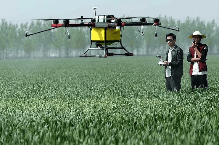
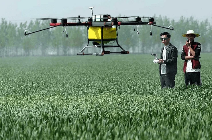
One of the most significant advancements in the field is the development of heavy-lift drones capable of carrying payloads of liquid fertilizers, herbicides, and pesticides. These drones use sophisticated software to follow pre-programmed flight paths, ensuring uniform coverage.
Unlike traditional crop dusters (manned aircraft) or tractor-mounted sprayers, drones can fly just a few meters above the crop canopy. This proximity minimizes "spray drift"—the wind-blown movement of chemicals to non-target areas—and ensures that the application is concentrated exactly where it is needed. In regions with rugged terrain or terraced fields, such as the rice paddies of Southeast Asia or the vineyards of Europe, drones provide a level of access that ground machinery simply cannot match.
3. Thermal Imaging and Irrigation Management
Water scarcity is an escalating concern for global agriculture. Drones equipped with thermal sensors can detect the temperature of the soil and the crops. Areas with high temperatures often indicate "evapotranspiration" issues, signaling that the plants are not receiving enough water. This data allows for the optimization of irrigation systems, ensuring that water is allocated to the driest sectors of the farm, thereby conserving a precious resource.
Economic Data and Market Projections
The economic impact of drone integration is substantial. According to industry reports from organizations like Fortune Business Insights and Goldman Sachs, the global agricultural drone market is projected to reach a valuation of over $5 billion by 2030, growing at a compound annual growth rate (CAGR) of approximately 20%.
The return on investment (ROI) for farmers is driven by several data points:
- Efficiency: A single drone can spray up to 10 hectares of land in an hour, a task that would take a human laborer an entire day to complete manually.
- Input Reduction: Precision application can reduce chemical usage by up to 30%, significantly lowering the "input costs" that often squeeze farm profit margins.
- Yield Increase: By identifying and treating crop health issues early, drones have been shown to increase overall crop yields by an average of 5% to 15%, depending on the crop type and region.
Institutional Responses and Regulatory Frameworks
Governments and international agricultural bodies have begun to recognize the strategic importance of drone technology. In India, the "Drone Shakti" initiative was launched to promote "Drones as a Service" (DRaaS), providing subsidies to farmers and startups to encourage adoption. Similarly, the European Union’s "Green Deal" emphasizes the role of precision tech in reducing the environmental footprint of farming.
However, the path to widespread adoption is not without hurdles. Regulatory bodies, such as the Federal Aviation Administration (FAA) in the United States and the European Union Aviation Safety Agency (EASA), maintain strict rules regarding Beyond Visual Line of Sight (BVLOS) flights and the weight of industrial drones.
"The technology is evolving faster than the regulations," notes an industry analyst from a leading ag-tech consultancy. "For drones to reach their full potential, we need standardized certification for operators and clearer guidelines on autonomous flight in rural airspaces. We are seeing progress, but it remains a bottleneck for large-scale corporate farming operations."
Overcoming Challenges: Cost and Education
Despite the clear benefits, two primary challenges remain: the initial capital expenditure (CAPEX) and the digital divide. A high-end agricultural drone system, including the aircraft, sensors, and data processing software, can cost between $10,000 and $50,000. For smallholder farmers, particularly in developing nations, this price tag is prohibitive.
To mitigate this, a "sharing economy" model has emerged. Agricultural cooperatives and private service providers now offer drone-on-hire services, allowing farmers to benefit from the technology without the burden of ownership or maintenance.
Furthermore, operating these systems requires a blend of traditional agronomy and modern data science. Educational institutions and agricultural extension offices are increasingly offering "Ag-Tech" certifications to train the next generation of farmers. The goal is to transform the image of farming from a labor-intensive "low-tech" profession into a data-driven "high-tech" career, which is essential for attracting younger generations back to the agricultural sector.
Environmental Impact and Climate Resilience
Perhaps the most compelling argument for drone technology is its role in climate change adaptation. As weather patterns become more erratic, the ability to monitor soil moisture and crop health in real-time becomes a survival tool. Drones allow for "variable rate application," meaning chemicals are only used where absolutely necessary, which prevents nitrogen runoff into local waterways and protects biodiversity.
Furthermore, specialized "seeding drones" are being used for reforestation projects and to plant cover crops that prevent soil erosion. By automating the distribution of seed pods in hard-to-reach areas, drones are helping to restore ecosystems at a speed and scale that manual planting could never achieve.
Conclusion: A New Era for Global Food Security
The rise of drones in agriculture signifies a shift toward a more sustainable, efficient, and resilient food production system. By moving the focus from the ground to the sky, the agricultural industry is gaining a level of foresight and precision that was unimaginable a generation ago.
While challenges regarding regulation and initial costs persist, the trajectory is clear. Drone technology is no longer a futuristic novelty; it is a vital industrial tool. As the global population continues to grow and arable land becomes more precious, the data-driven insights provided by these "pahlawan kecil di langit" (small heroes in the sky) will be instrumental in ensuring that the world can feed itself in the decades to come. The future of farming is indeed being written in the clouds, but the benefits are firmly rooted in the earth.