The global agricultural landscape is currently undergoing a profound technological renaissance, transitioning from traditional labor-intensive methods to a high-tech, data-driven era often referred to as Agriculture 4.0. Central to this transformation is the Unmanned Aerial Vehicle (UAV), commonly known as the drone. Once reserved for military surveillance and high-end cinematography, drones have emerged as indispensable tools for modern farmers, offering solutions to age-old challenges such as labor shortages, resource waste, and the unpredictable impacts of climate change. As the global population is projected to reach nearly 10 billion by 2050, the integration of drone technology in the agricultural sector is no longer a luxury but a strategic necessity to ensure food security and sustainable production.
The Historical Trajectory of Aerial Technology in Agriculture
The use of aerial technology in farming is not entirely new, but its accessibility and sophistication have evolved dramatically over the last four decades. In the 1980s, Japan was a pioneer in this field, introducing the Yamaha R-50, a remote-controlled helicopter designed specifically for crop dusting. However, these early models were expensive, bulky, and required highly specialized operators.
The real turning point occurred in the early 2010s with the convergence of miniaturized GPS technology, high-capacity lithium-polymer batteries, and advanced flight controllers. By 2015, the Federal Aviation Administration (FAA) in the United States and similar regulatory bodies globally began streamlining the commercial use of drones, paving the way for specialized agricultural platforms. Today, the market features sophisticated octocopters and fixed-wing drones capable of carrying significant payloads or high-resolution multispectral sensors, marking a shift from simple aerial observation to active field intervention and precision analytics.
Core Functional Capabilities: Beyond Visual Observation
The utility of drones in contemporary farming extends far beyond taking aerial photographs. They serve as multifaceted platforms for data collection and physical labor, categorized into several critical functions:
Precision Multispectral Imaging and Crop Health Analysis
Modern agricultural drones are frequently equipped with multispectral sensors that capture data across various light wavelengths, including near-infrared (NIR). This allows for the calculation of the Normalized Difference Vegetation Index (NDVI), a graphical indicator that identifies the "greenness" or photosynthetic activity of plants. By analyzing NDVI maps, agronomists can detect physiological stress in crops—caused by nutrient deficiencies, water stress, or pest infestations—long before it becomes visible to the human eye. This early detection capability allows for localized intervention, preventing the spread of disease and reducing the need for blanket chemical applications.
Variable Rate Technology (VRT) in Spraying and Seeding
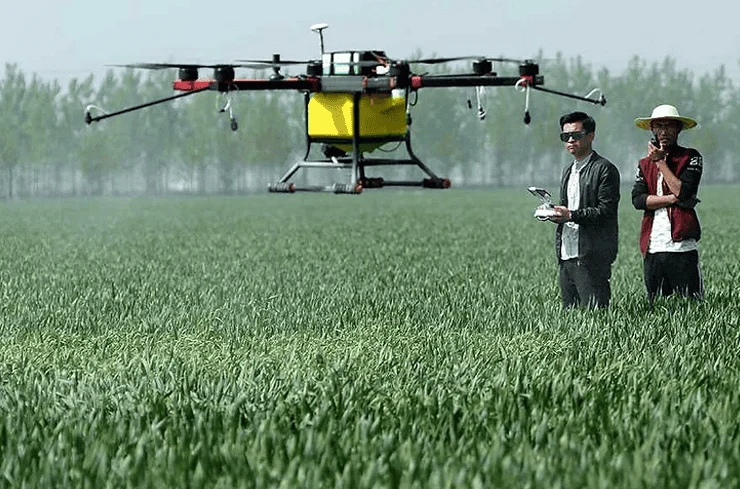
One of the most significant advancements in drone hardware is the development of heavy-lift spraying drones. Unlike traditional tractor-mounted sprayers that apply chemicals uniformly across a field, drones utilizing Variable Rate Technology (VRT) can adjust the volume of fertilizer or pesticide delivered based on real-time data from their onboard sensors. This precision ensures that only the areas requiring treatment receive it, which significantly reduces chemical runoff into local water systems and lowers input costs for the farmer. Furthermore, drones are increasingly used for "drone seeding," particularly in reforestation projects or for planting cover crops in terrain that is too rugged or wet for ground-based machinery.
High-Resolution Mapping and Topographical Analysis
Drones provide the ability to generate highly accurate 3D maps of agricultural terrain through photogrammetry or LiDAR (Light Detection and Ranging). These maps are essential for irrigation planning, as they reveal the natural drainage patterns of the land and identify areas prone to waterlogging or erosion. By understanding the literal "lay of the land," farmers can optimize their irrigation infrastructure, leading to significant water savings and improved soil health.
Quantitative Impact: Supporting Data and Economic Efficiency
The adoption of drone technology is supported by compelling data regarding operational efficiency. According to industry reports from organizations like the Food and Agriculture Organization (FAO) and various agricultural tech analysts, drone-based spraying can be up to 40 to 60 times faster than manual backpack spraying. In a standard operational scenario, a single drone can cover between 7 to 10 hectares per hour, a task that would take a human laborer several days to complete with less uniformity.
Furthermore, the economic implications are substantial. Research indicates that precision drone application can reduce pesticide use by up to 30% and water consumption by up to 90% compared to traditional methods. For large-scale commercial operations, this translates into millions of dollars in saved input costs over a single growing season. The global agricultural drone market reflects this value proposition; it was valued at approximately $1.5 billion in 2022 and is projected to expand at a compound annual growth rate (CAGR) of over 20% through 2030, potentially reaching a valuation of $5-6 billion as hardware costs continue to decrease and software capabilities improve.
Stakeholder Perspectives and Institutional Responses
The integration of drones into the agricultural workflow has garnered diverse reactions from various stakeholders. Government agricultural departments in nations like India, China, and Brazil have launched subsidy programs to encourage drone adoption among smallholder farmers, recognizing the technology’s potential to boost national food yields.
"The drone is the new tractor," says a representative from a leading global ag-tech consortium. "Just as the transition from animal labor to internal combustion engines revolutionized the 20th century, the transition to autonomous aerial systems is defining the 21st. We are seeing a democratization of data where even a farmer with a modest plot can have the same level of insight as a massive industrial plantation."
However, environmental groups emphasize the need for strict regulations regarding chemical drift. While drones are more precise, the fine mist created by aerial rotors can be susceptible to wind. In response, manufacturers have developed sophisticated "anti-drift" nozzles and automated weather-monitoring software that prevents the drone from operating if wind speeds exceed safe thresholds.
Navigating Challenges: Regulations, Cost, and Literacy
Despite the clear benefits, the path to universal adoption is not without obstacles. The primary barrier for many independent farmers remains the initial capital investment. While prices have fallen, a professional-grade agricultural drone system—including batteries, charging stations, and specialized software licenses—can still cost between $10,000 and $50,000.
Beyond financial constraints, the regulatory landscape remains complex. Operators must often obtain commercial pilot licenses and adhere to strict "Line of Sight" (LOS) regulations, which limit the distance a drone can fly from the pilot. Furthermore, "digital literacy" presents a challenge in rural areas where older generations of farmers may be hesitant to adopt complex software interfaces. To combat this, a new service-based economy has emerged, where specialized "drone-as-a-service" companies are hired by farmers to perform mapping and spraying, removing the need for the farmer to own or operate the equipment personally.
Future Implications: AI Integration and Autonomous Swarms
Looking toward the horizon, the next phase of agricultural drones involves the integration of Artificial Intelligence (AI) and "swarming" technology. Swarm intelligence allows multiple drones to communicate with one another and work collaboratively to cover vast areas in a fraction of the time. AI algorithms are also becoming more adept at "predictive analytics," where the software can analyze years of historical drone data to predict future crop yields with over 90% accuracy.
The environmental impact of this evolution is also noteworthy. As drones are predominantly electric, their widespread use reduces the carbon footprint of the agricultural sector by replacing diesel-powered tractors for many tasks. This aligns with global "Green Deal" initiatives and sustainability goals, positioning drones as a key player in the fight against climate-driven food instability.
Conclusion: A New Vantage Point for Global Food Security
The emergence of drones in the world of agriculture represents a fundamental shift in how humanity interacts with the land. By providing a "bird’s-eye view" coupled with surgical precision, these machines are enabling a level of resource management that was previously unimaginable. They bridge the gap between the soil and the data center, turning every acre into a source of actionable intelligence.
While challenges regarding regulation and cost persist, the trajectory is clear: the future of farming is elevated. As technology continues to mature, the drone will cease to be a novelty and will become as common a sight in the countryside as the plow. In the pursuit of a sustainable and food-secure future, the pahlawan kecil (little heroes) in the sky are proving that the best way to care for the earth is often to watch over it from above. The synergy of technology in the sky and labor on the ground ensures that the benefits are felt where they matter most—in the yields that feed the world.