The record-breaking heatwaves that have recently swept across the southern counties of England have highlighted a growing disparity in public health and urban comfort, a phenomenon now being documented through the lens of traditional analog photography and environmental observation. As temperatures consistently exceeded 30°C for a period of three consecutive weeks, the regional infrastructure and the domestic habits of residents were forced to adapt to a climate more commonly associated with Mediterranean latitudes. This period of extreme weather has provided a stark backdrop for analyzing the "politics of deep shade," a term used to describe the unequal access to cooling environments and green infrastructure in modern urban and suburban landscapes.
The Chronology of a Heatwave: Three Weeks of Thermal Stress
The meteorological event in question began in mid-summer, characterized by a high-pressure system that became stationary over the British Isles. For twenty-one days, the southern counties experienced a relentless climb in mercury, with daily peaks frequently crossing the 30°C threshold. The impact on daily life was immediate and profound, necessitating a shift in the traditional British schedule to accommodate the hazards of heat exhaustion and dehydration.
During the first week of the heatwave, residents began implementing "thermal management" strategies within their homes. This involved a precise routine of ventilation and insulation. Observations from the field indicate that households would open all available apertures between the hours of 4:00 AM and 7:00 AM to capitalize on the nocturnal cooling of the air. As soon as internal sensors or thermometers indicated a rise of even 0.1°C—signaling that the external ambient temperature had surpassed the internal temperature—windows were sealed and heavy curtains were drawn, particularly on southern-facing elevations. This methodology allowed for the maintenance of a "thermal reservoir" of cooler air, making indoor environments bearable without the widespread use of air conditioning, which remains a luxury or a rarity in many UK residential buildings.
By the second and third weeks, the cumulative effect of the heat began to alter the public sphere. High-street footfall decreased during peak sun hours, and recreational spaces became deserted. It was during this phase that the visual documentation of the crisis began, focusing on the interplay between light, shadow, and the accessibility of shaded refuges.
The Photographic Methodology: Applying the Zone System to Extreme Light
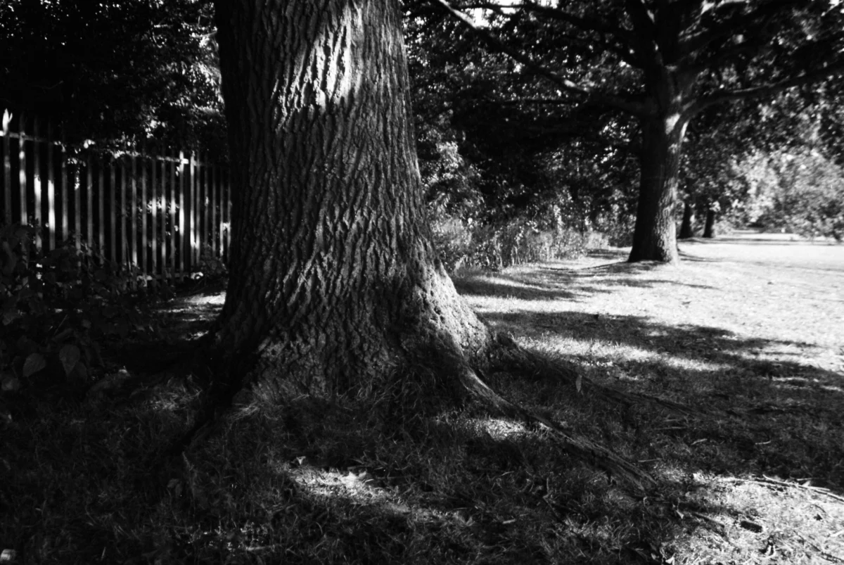
In an effort to document the environmental conditions, photographic studies were conducted using traditional 35mm silver-halide technology. Specifically, the use of a Centon DF-300—a mechanical SLR and a recognized clone of the Minolta X-300—provided a platform for technical experimentation under extreme lighting conditions. Utilizing Fomapan 100, a traditional black-and-white film known for its fine grain and classical tonal range, the project sought to map the "Zone System" of exposure as defined by Ansel Adams and Fred Archer.
The Zone System is a photographic technique for determining optimal exposure and development, providing a systematic method for defining the relationship between the way a photographer visualizes a subject and the final results. In the context of a 30°C heatwave, this involved metering the extreme contrast between "scorched grass" (high-key highlights) and the "deep shade" of mature tree canopies (low-key shadows).
The technical challenge was significant. Unlike modern digital cameras, the Centon DF-300 lacks "live view" capabilities, histograms, or instant review screens. The photographer relied entirely on a series of light-emitting diodes (LEDs) within the viewfinder to gauge the intensity of the light. By metering back and forth between the sun-drenched areas and the shaded recesses, the study aimed to find a balance that would prevent the loss of detail in the highlights while maintaining texture in the shadows. This process required the photographer to remain in the shade of large trees, as the direct sunlight was deemed too hazardous for prolonged exposure.
The Politics of Deep Shade: Socioeconomic Implications
The term "the politics of deep shade" emerged as a critical observation during these photographic excursions. As the heat rendered urban centers nearly uninhabitable, a clear divide became apparent between those with access to wooded, recreational spaces and those confined to "urban heat islands."
Urban heat islands (UHI) are metropolitan areas that are significantly warmer than their surrounding rural areas due to human activities and the prevalence of heat-absorbing materials like asphalt, concrete, and brick. In the southern counties, the presence of mature tree lines—such as those found alongside railway corridors or riverbanks—offered a vital ecological service. These areas provided "deep shade," where the temperature could feel several degrees cooler than the surrounding streets.
However, data suggests that access to such shade is not distributed equitably. In many commercialized urban centers, wooded space is often categorized as a luxury rather than a public utility. Mature trees require decades to grow and significant investment to maintain, making them more common in affluent suburbs or protected historical districts. Conversely, high-density housing developments and industrial zones often lack significant canopy cover, leaving residents vulnerable to the full force of solar radiation.
The observation that parks and streets appeared as deserted as they did during the COVID-19 pandemic highlights the social isolation caused by extreme heat. When the outdoors becomes a hostile environment, the "public square" effectively disappears, leaving only those with the means to access private or exclusive shaded areas with any semblance of quality of life.
Supporting Data: The Rising Cost of Cooling
Statistical analysis from environmental agencies underscores the severity of the situation. According to the UK’s Climate Change Committee (CCC), the number of heat-related deaths in the UK could triple by 2050 if significant adaptations are not made to the built environment. The "costing" of wooded space mentioned in the documentation refers to the economic valuation of ecosystem services. While a row of trees may be viewed by developers as a hindrance to maximum land utilization, their value in reducing ambient temperatures and lowering energy costs for cooling is substantial.
Current data on urban canopy cover in England shows a wide variance. Some leafy boroughs boast a canopy cover of over 25%, while more industrial or impoverished areas may have less than 5%. During a three-week heatwave at 30°C, this 20% difference in tree cover translates directly into a public health crisis. The "deep shade" found by the river and the railway line in this study represents a critical piece of green infrastructure that serves as a thermal refuge for the local population.
Official Responses and Infrastructure Challenges
Local government responses to the heatwave have focused on immediate safety, such as issuing "Level 3" heat-health alerts. However, long-term urban planning is increasingly coming under scrutiny. Urban planners and environmental scientists have argued that "green corridors"—continuous strips of vegetation like the one documented alongside the railway line—are essential for climate resilience.
Inferred reactions from public health officials suggest that "heat equity" will become a central pillar of future urban policy. This includes the preservation of mature trees, which provide significantly more cooling through evapotranspiration and shade than saplings. The photographic evidence of "scorched grass" adjacent to "deep shade" serves as a visual metaphor for the binary nature of the modern climate: a world of extremes where the presence or absence of a tree canopy determines the habitability of a space.
Technical Analysis and Photographic Processing
The documentation of this event was finalized through traditional chemical processing. The Fomapan 100 film was developed by Photo Hippo Lab in Burnley, Lancashire, a facility specializing in analog preservation. The choice of a professional lab for developing and scanning ensures that the nuances of the Zone System experimentation are preserved, providing a high-fidelity record of the light intensities present during the heatwave.
The use of a wide-angle lens allowed the photographer to capture the scale of the shaded areas relative to the open, sun-bleached fields. This perspective emphasizes the protective nature of the canopy, portraying the trees not just as aesthetic elements, but as structural shields against the environment.
Implications for the Future
The "politics of deep shade" is likely to remain a defining issue as global temperatures continue to rise. The three-week heatwave in southern England was not an isolated anomaly but part of a documented trend toward more frequent and intense thermal events. As these cycles of extreme heat become a regular feature of the British summer, the management of shaded spaces will transition from a matter of landscaping to a matter of survival.
For those trapped in overheating urban areas without access to the "luxuries" of mature wooded spaces, the world may indeed become unbearable. The photographic record of this period serves as both a technical study in light and shadow and a social commentary on the necessity of environmental equity. As the photographer noted, the ability to manage in a world governed by heat is increasingly dependent on one’s proximity to the cool air of the deep shade—a resource that must be protected and expanded for all members of society, regardless of socioeconomic standing.