The global agricultural landscape is currently undergoing a seismic shift as traditional farming methodologies are augmented by high-precision Unmanned Aerial Systems (UAS), commonly referred to as drones. For decades, the image of farming was synonymous with heavy machinery, manual labor, and ground-based observations, yet the emergence of specialized agricultural drones has introduced a sophisticated aerial dimension to crop management. These devices, once relegated to military or recreational use, are now essential tools for optimizing yields, reducing resource waste, and ensuring food security in an era of climate volatility. As the agricultural drone market continues to expand—projected to reach a valuation of several billion dollars by the end of the decade—farmers across the globe are transitioning from intuitive guesswork to data-driven decision-making.
The Technological Evolution of Precision Agriculture
The journey of drones into the agricultural sector is part of a broader movement known as "Precision Agriculture." This approach relies on observing, measuring, and responding to inter- and intra-field variability in crops. While satellite imagery has been used for this purpose since the late 20th century, drones offer a significant advantage: resolution. Satellites can be obscured by cloud cover and often provide images with a resolution of several meters per pixel. In contrast, low-flying drones can capture data at a sub-centimeter level, providing a granular view of every individual plant in a field.
The chronology of this integration began in the early 2010s when early adopters started strapping multispectral cameras to hobbyist drones. By 2015, companies like DJI and XAG began manufacturing purpose-built agricultural drones designed for heavy-duty spraying and sophisticated mapping. Today, these systems are integrated into "AgStack" software ecosystems, where flight paths are automated, and data is uploaded to the cloud for immediate analysis via Artificial Intelligence (AI).
Core Functionalities and Operational Benefits
The utility of drones in modern farming is multifaceted, addressing several critical stages of the crop lifecycle. These functions are generally categorized into three main pillars: monitoring, application, and analysis.
1. High-Resolution Mapping and Real-Time Monitoring
One of the most immediate benefits of drone technology is the ability to conduct rapid aerial surveys. A drone can scout a 100-acre farm in less than 20 minutes, a task that would take a human scout hours or even days to complete on foot. Through high-definition video and photography, farmers can identify "stress zones" caused by irrigation leaks, soil compaction, or localized pest infestations.
Beyond simple visual checks, drones generate Digital Surface Models (DSMs) and 3D maps. These tools allow farmers to analyze the topography of their land, identifying areas prone to water pooling or erosion. This information is vital for designing efficient drainage systems and optimizing the placement of crops based on the terrain.
2. Precision Chemical and Nutrient Application
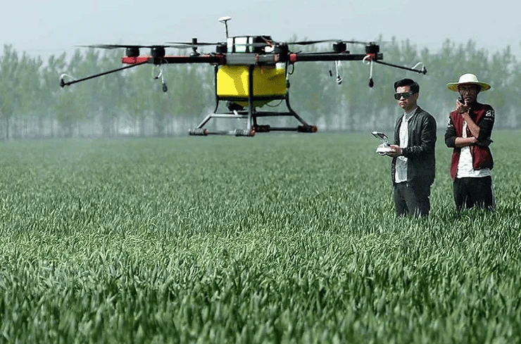
The use of drones for the application of liquid fertilizers, pesticides, and herbicides represents a major leap in operational efficiency. Traditional crop-dusting planes are expensive and imprecise, while tractor-mounted sprayers can damage crops and compact the soil.
Agricultural spraying drones are equipped with ultrasonic sensors and LiDAR (Light Detection and Ranging) to maintain a constant altitude above the crop canopy, even on uneven terrain. This ensures that the application is uniform. Furthermore, drones utilize "Variable Rate Application" (VRA) technology. By using data from previous mapping flights, the drone can be programmed to spray only the areas that need treatment, rather than blanket-spraying the entire field. Industry data suggests that this precision can reduce chemical usage by up to 30% to 40%, significantly lowering costs and minimizing the environmental footprint of the farm.
3. Multispectral Imaging and Plant Health Diagnostics
The most advanced drones are equipped with multispectral and hyperspectral sensors. These cameras capture light waves beyond the visible spectrum, specifically the Near-Infrared (NIR) band. The health of a plant can be determined by how it reflects NIR light; healthy plants with high chlorophyll content reflect more NIR light than stressed or diseased plants.
By processing this data, drones generate a Normalized Difference Vegetation Index (NDVI) map. This color-coded map acts as a "heat map" for plant health. Farmers can see early signs of nitrogen deficiency or fungal infections days or even weeks before they are visible to the naked eye. This early detection allows for targeted intervention, often saving crops that would otherwise have been lost.
Supporting Data and Market Projections
The economic argument for drone adoption is supported by robust industry statistics. According to a report by Grand View Research, the global agricultural drone market size was valued at approximately USD 1.5 billion in 2022 and is expected to grow at a compound annual growth rate (CAGR) of over 20% through 2030.
In terms of return on investment (ROI), case studies from corn and soybean farms in the United States and rice paddies in Southeast Asia indicate that drone-assisted scouting and precision spraying can increase net profits by $7 to $15 per acre. This is achieved through a combination of reduced input costs (chemicals and water) and increased yield totals. Furthermore, the safety aspect cannot be overlooked; by using drones for spraying, the exposure of farmworkers to potentially toxic chemicals is reduced by nearly 90%.
Industry Perspectives and Regulatory Responses
Agronomists and industry experts have voiced strong support for the technology while noting the need for a supportive regulatory framework. Dr. Elena Rodriguez, a specialist in AgTech systems, notes, "Drones are the bridge between the physical field and digital management. They provide the ‘eyes’ that make AI-driven farming possible. However, the true value is not in the drone itself, but in the data it collects and how that data is integrated into the farmer’s daily workflow."
Governments are also responding to this technological surge. The Federal Aviation Administration (FAA) in the United States has streamlined Part 107 waivers for agricultural operations, allowing for "swarming"—where one pilot operates multiple drones simultaneously. In the European Union, EASA is working on harmonizing rules to allow for heavier spraying drones to operate across borders. In emerging markets like India and Indonesia, government subsidies are being introduced to help smallholder cooperatives purchase drones, recognizing their potential to boost national food security.
Challenges to Widespread Adoption
Despite the clear advantages, the path to universal adoption faces several hurdles. The primary barrier is the initial capital expenditure. A professional-grade spraying drone, complete with batteries, charging stations, and software subscriptions, can cost between $10,000 and $30,000. For small-scale farmers, this is often prohibitive without government assistance or the use of "Drone-as-a-Service" (DaaS) providers.
Technical expertise is another significant challenge. Operating a drone for precision agriculture requires more than just piloting skills; it requires an understanding of data analysis and GIS (Geographic Information Systems). While manufacturers are making software more user-friendly, there remains a steep learning curve for traditional farmers. Additionally, rural connectivity remains an issue; in many remote agricultural regions, the lack of high-speed internet makes it difficult to upload and process the massive amounts of data generated by multispectral sensors.
Future Implications: Climate Change and Food Security
Looking ahead, the role of drones will likely expand from a "luxury" tool to a necessity for survival in the face of climate change. As weather patterns become more unpredictable, the ability to monitor soil moisture levels in real-time will be crucial for water conservation. Drones can help identify the exact moment a crop needs irrigation, preventing water waste in drought-prone areas.
Furthermore, the integration of AI will allow drones to perform autonomous "spot-treatments." Imagine a swarm of drones that can identify an invasive weed species and eliminate it without touching the surrounding crop. This level of autonomy will be vital as the global population is expected to reach nearly 10 billion by 2050, requiring a 70% increase in food production.
Conclusion: A New Era Above the Soil
The rise of drones in agriculture signifies a paradigm shift where technology and nature work in closer harmony. By providing a bird’s-eye view of the farm, these aerial tools empower farmers to be more efficient, more profitable, and more sustainable. While the "drone revolution" is still in its early stages, the benefits to the earth and the global food supply are already becoming clear. The future of farming is no longer just about what happens on the ground; it is increasingly defined by the technology patrolling the skies. As costs continue to fall and AI capabilities rise, the drone will soon be as common on the farm as the tractor, serving as a silent guardian of the world’s most vital industry.