Google has officially launched a groundbreaking update to its renowned geospatial platform, Google Earth, by integrating the advanced Nano Banana AI image generator. This innovative addition empowers users to transcend static satellite imagery, allowing them to dynamically visualize any chosen geographic location in a multitude of styles, historical eras, or speculative future scenarios directly within the application. The announcement, made on July 30, 2026, marks a significant leap in interactive digital exploration and sets a new precedent for how individuals and professionals engage with geographical data.
The Dawn of Dynamic Geographic Visualization
The integration of Nano Banana AI represents a paradigm shift from passive viewing to active, generative exploration within Google Earth. Traditionally, Google Earth has served as a digital atlas, meticulously mapping our planet with satellite, aerial, and street-level imagery. With Nano Banana AI, this robust dataset becomes the canvas for artificial intelligence to paint new realities. Users can now input text prompts, much like popular standalone AI image generators, and watch as the underlying landscape is transformed into hyper-realistic historical reconstructions, stylized artistic interpretations, or detailed architectural proposals. This functionality leverages Google’s extensive computational power and vast repositories of imagery, combined with state-of-the-art generative adversarial networks (GANs) or diffusion models, to produce contextually relevant and visually compelling outputs. The immediate availability of this feature to all Google Earth users underscores Google’s commitment to democratizing advanced AI tools for a global audience.
Reimagining History: The Pompeii Example
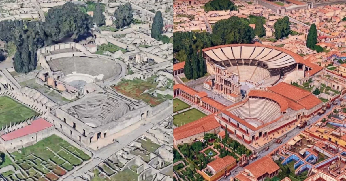
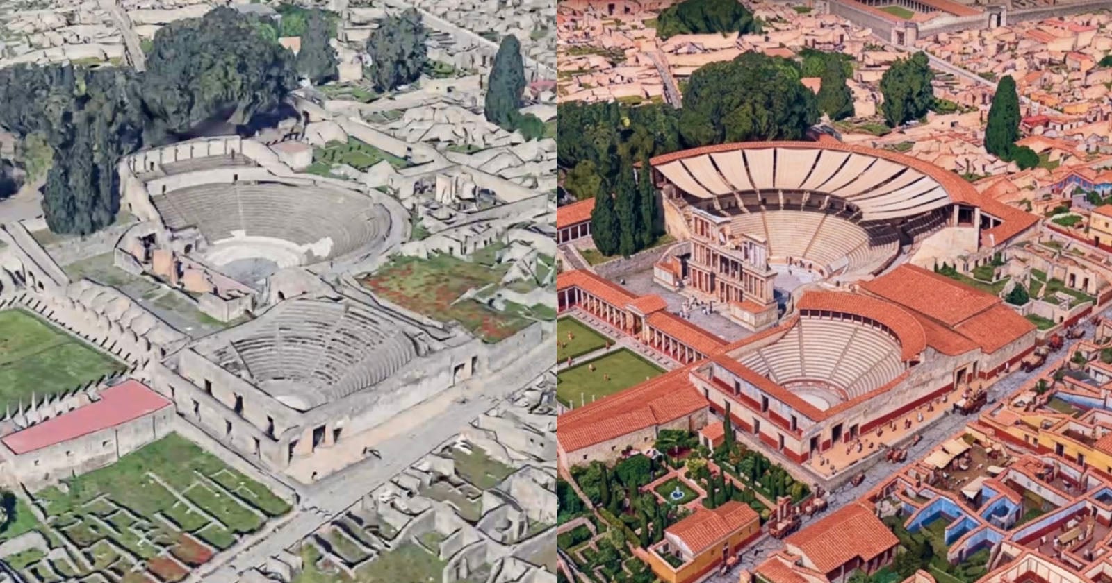
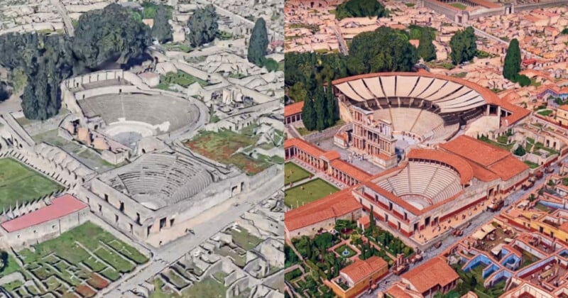
One of the most compelling applications highlighted by Google is the ability to resurrect historical landscapes. The ancient Roman city of Pompeii, famously preserved in ash after the eruption of Mount Vesuvius in 79 A.D., serves as a prime example. While Google Earth currently displays the archaeological ruins as they stand today, the Nano Banana AI allows users to issue a prompt such as "render a hyper-realistic view of what these Pompeii ruins looked like in 78 A.D." The AI then processes the current topographical and structural data, cross-referencing it with historical and architectural knowledge embedded in its training data, to generate a vivid, imagined reconstruction of the bustling city prior to its catastrophic demise.
This capability is poised to revolutionize historical education and archaeological research. Students can move beyond textbooks and static images, experiencing an immersive, dynamic visualization of ancient civilizations. Historians and archaeologists, while recognizing the generative nature of the output, could use such a tool for preliminary visualization hypotheses or to engage the public with their findings in a more accessible way. The ability to toggle between the present-day ruins and a painstakingly reconstructed past offers an unparalleled educational experience, fostering a deeper understanding of historical events and urban development.
Informative Infographics and Data Visualization
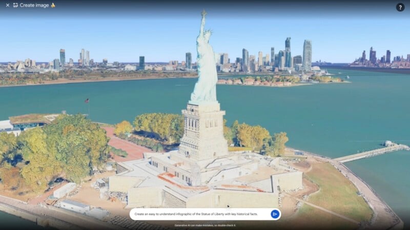
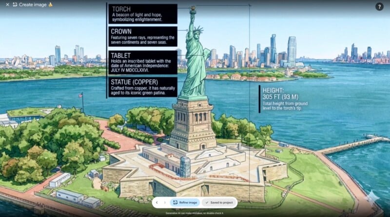
Beyond historical reconstruction, Nano Banana AI extends its utility to practical data visualization. Google demonstrated this by transforming an aerial view of the Statue of Liberty into a cartoonish, yet highly informative, infographic. A simple prompt could request "create an infographic detailing the Statue of Liberty’s construction materials, height, and key features in an illustrative style." The AI would then not only stylize the image but also overlay relevant data points, labels for components like the torch, crown, and tablet, and provide statistical information such as its impressive 305-foot height.
This feature holds immense potential for educational content creation, journalistic reporting, and public information campaigns. It streamlines the process of creating visually engaging data representations that are spatially anchored. However, Google prudently includes a crucial disclaimer with these generated infographics: "Generative AI can make mistakes, so double-check it." This acknowledgment is vital, reminding users of the inherent limitations of AI and the imperative for human verification, especially when dealing with factual information. The rapid pace of AI development means that while these tools are powerful, they are not infallible and can sometimes "hallucinate" or misinterpret data.
Professional Applications: Urban Planning and Real Estate
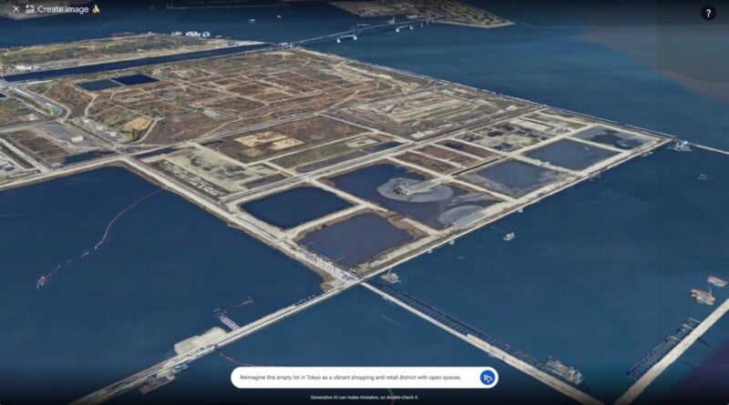
The professional implications of Nano Banana AI are particularly significant for sectors like architecture, urban planning, and real estate. The tool offers a transformative way to visualize proposed developments and bring conceptual plans to life. Google illustrates this with an example of an empty lot in Tokyo. An architect or urban planner can prompt the AI with "Reimagine this empty lot in Tokyo as a vibrant shopping and retail district with open spaces." The barren concrete landscape is then supplanted by a high-quality 3D rendering of a bustling urban oasis, complete with modern buildings, green spaces, and integrated infrastructure.
This capability drastically shortens the visualization phase of projects, enabling stakeholders to rapidly iterate on design ideas and present compelling visuals to clients, investors, and regulatory bodies. For real estate professionals, it means transforming vacant land or existing properties into idealized future states, making listings more attractive and helping potential buyers envision possibilities before any ground is broken. Similarly, individuals planning personal projects, such as a lakeside dream home, can use the AI to generate a photorealistic rendering of their proposed cabin nestled perfectly within the natural landscape, offering a tangible preview of their vision. This reduces uncertainty and facilitates more informed decision-making in the early stages of design and development.
Creative Expression and Niche Visualizations
Beyond the practical and professional applications, Nano Banana AI also caters to pure creative expression and niche artistic styles. The example of an X (formerly Twitter) user sharing their home city "in crochet mode" demonstrates the whimsical and customizable nature of the tool. Users can experiment with various artistic filters, textures, and styles, transforming familiar landscapes into imaginative artworks. This fosters a new dimension of user engagement, turning Google Earth into a creative sandbox where geographical data meets artistic interpretation. From watercolor renderings to futuristic cityscapes, the possibilities are limited only by the user’s imagination and the AI’s interpretive capabilities. This democratizes high-quality image generation, making sophisticated visual transformations accessible to anyone with an internet connection.
The Technology Behind Nano Banana AI
While Google has not fully disclosed the intricate details of the "Nano Banana AI" moniker, it likely signifies a highly optimized and efficient generative AI model tailored for geospatial data. The "Nano" suggests a focus on computational efficiency, potentially allowing for rapid generation directly within the user’s browser or device, or indicating a highly optimized server-side processing system. The "Banana" could be a playful codename, typical of Google’s internal project naming conventions, or subtly hint at a specific architectural characteristic or training methodology of the AI.
The core technology undoubtedly relies on Google’s deep expertise in computer vision, machine learning, and vast datasets. Google Earth’s existing 3D imagery, derived from aerial photography and photogrammetry, provides an incredibly rich and accurate foundation. Nano Banana AI likely processes these existing 3D models and 2D textures, applying generative techniques to alter features, add structures, modify environmental elements (like vegetation or water bodies), and even simulate lighting conditions based on the user’s prompt. This integration showcases Google’s broader strategy of infusing AI across its product ecosystem, making advanced capabilities readily available to its massive user base.
Strategic Context and Broader Implications
The introduction of Nano Banana AI into Google Earth is not an isolated event but rather a strategic move within Google’s overarching vision for artificial intelligence and its interaction with the physical world. It underscores a trend towards more immersive, interactive, and personalized digital experiences.
Educational Transformation: The most immediate and profound impact will likely be felt in education. By offering dynamic, visual reconstructions of historical sites, scientific phenomena, or cultural landmarks, Google Earth with Nano Banana AI can transform passive learning into active discovery. It allows students to "visit" ancient Rome, visualize geological formations, or understand urban development patterns in an unprecedented way. Educators will need to guide students in distinguishing between AI-generated interpretations and verified historical or scientific facts, fostering critical thinking skills alongside immersive learning.
Economic and Professional Impact: For industries like architecture, construction, urban planning, and real estate, the tool offers significant efficiency gains and new creative avenues. Project visualization, client presentations, and preliminary design iterations can be dramatically accelerated, potentially reducing costs and improving design outcomes. The tourism industry could also leverage this to offer "virtual tours" of destinations, showcasing both their current state and historical grandeur.
Ethical Considerations and Challenges: As with all powerful AI tools, Nano Banana AI presents ethical considerations. The disclaimer about AI making mistakes is crucial. The potential for misinformation, particularly with historical or scientific reconstructions, necessitates responsible usage and critical evaluation. The distinction between "hyper-realistic imagining" and "factual representation" must always be clear. There are also broader concerns about the potential for deepfakes or misleading visualizations if the technology were to be misused or deployed without appropriate safeguards. Google will likely face ongoing scrutiny regarding its content moderation policies and the transparency of its AI models. Furthermore, questions around intellectual property for AI-generated designs and visuals will become increasingly pertinent in professional contexts.
The Future of Geographic Exploration: Looking ahead, Nano Banana AI could evolve to include even more sophisticated functionalities, such as real-time environmental simulations (e.g., visualizing the impact of climate change over decades), interactive design elements, or even collaborative multi-user visualization sessions. It hints at a future where our digital interfaces with the world are not just mirrors of reality but dynamic, intelligent canvases that allow us to explore possibilities, understand complexities, and unleash creativity.
Conclusion
The integration of Nano Banana AI into Google Earth marks a pivotal moment in the evolution of digital mapping and AI-powered visualization. From resurrecting ancient cities to designing future urban landscapes and fostering creative expression, this tool redefines how we interact with geographical information. While promising immense benefits across education, professional industries, and personal exploration, its responsible deployment and the critical engagement of its users will be paramount. Google Earth, once a window to our world, has now become a portal to infinite possibilities, inviting users to not just observe but to reimagine and interact with the planet in ways previously confined to science fiction. The future of geographic discovery has truly begun.