The adoption of drone technology in agriculture is not merely a trend but a response to several converging global pressures. As the world’s population is projected to reach nearly 10 billion by 2050, the agricultural industry must increase production by approximately 70% to maintain food security. Simultaneously, farmers are grappling with labor shortages, rising input costs, and the unpredictable effects of climate change. In this context, drones provide a scalable solution to optimize resource use, reduce waste, and increase crop yields through high-precision monitoring and intervention.
The Evolution of Agricultural Aerial Surveillance
The chronology of drones in agriculture began in earnest in the early 2010s, following the miniaturization of GPS technology and the development of lightweight lithium-polymer batteries. Initially, these devices were limited to basic aerial photography, allowing farmers to spot visible patches of dry soil or pest infestations. However, the true turning point occurred around 2016, when the United States Federal Aviation Administration (FAA) introduced Part 107 regulations, providing a legal framework for commercial drone operations. This sparked a wave of innovation among Ag-Tech companies, leading to the integration of multispectral sensors and sophisticated software capable of analyzing crop health beyond the capabilities of the human eye.
By 2020, the focus shifted from simple data collection to "autonomous intervention." This era saw the rise of heavy-lift drones capable of carrying payloads for liquid spraying and granular spreading. Today, the industry is entering a phase of total integration, where drones operate as part of a connected ecosystem involving Internet of Things (IoT) sensors, autonomous tractors, and AI-driven analytics platforms.
Core Functional Capabilities of Agricultural UAVs
The utility of drones in modern farming can be categorized into three primary pillars: advanced monitoring, precision application, and resource management.
1. Multispectral Imaging and Crop Health Analysis
Standard cameras capture light in the visible spectrum (RGB), but drones used in agriculture are frequently equipped with multispectral sensors. These sensors capture data in the near-infrared (NIR) and short-wave infrared bands. Plants reflecting high levels of NIR light are typically healthy and photosynthetically active, while stressed plants absorb more of it.
By calculating the Normalized Difference Vegetation Index (NDVI), drones can generate "heat maps" of a field. These maps allow farmers to identify issues such as nitrogen deficiencies, fungal infections, or water stress days or even weeks before they become visible to a scout on the ground. This early detection is critical for preventing widespread crop failure and reducing the need for "blanket" chemical treatments.
2. Precision Spraying and Seeding
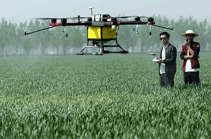
Traditional crop dusting via manned aircraft or ground-based tractors is often inefficient. Manned aircraft lack the precision to target specific rows, leading to chemical drift, while tractors compact the soil and can damage crops as they move through the field. Agricultural spraying drones solve these issues by flying at low altitudes—often just two to three meters above the crop canopy.
Equipped with ultrasonic sensors and LiDAR (Light Detection and Ranging), these drones can maintain a consistent height even over undulating terrain. They use specialized nozzles that produce ultra-fine droplets, ensuring maximum coverage with minimal liquid. Research indicates that drone-based spraying can reduce chemical consumption by up to 30% and water usage by up to 90% compared to traditional methods.
3. Irrigation and Soil Analysis
Water scarcity is one of the most significant challenges facing 21st-century agriculture. Drones equipped with thermal sensors can map the "temperature signature" of a field. Areas with high temperatures often indicate dry soil or plants that have closed their stomata due to water stress. This data allows for the creation of variable-rate irrigation maps, directing water only to the zones that require it, thereby conserving thousands of gallons of water per hectare.
Statistical Overview and Market Growth
The economic impact of drones in agriculture is supported by robust data. According to market research reports, the global agriculture drone market was valued at approximately $1.2 billion in 2020 and is projected to reach $5.7 billion by 2030, growing at a compound annual growth rate (CAGR) of over 18%.
Efficiency gains are equally quantifiable. A traditional manual inspection of a 100-hectare farm could take a human scout several days to complete with varying levels of accuracy. A fixed-wing drone can map that same area in less than 30 minutes, providing centimeter-level resolution. In terms of ROI (Return on Investment), studies in the Midwestern United States have shown that precision drone mapping can increase corn yields by an average of 5% to 10% by allowing for more timely nitrogen applications.
Stakeholder Perspectives and Regulatory Landscape
The integration of drones has elicited a variety of responses from industry stakeholders.
Farmers and Agronomists: While many large-scale operations have embraced the technology, smallholder farmers often cite the "barrier to entry" as a concern. The initial capital expenditure for a high-end spraying drone and the necessary data processing software can exceed $20,000. However, the rise of "Drone-as-a-Service" (DaaS) providers has mitigated this, allowing farmers to hire pilots on a per-acre basis rather than purchasing the hardware themselves.
Regulatory Bodies: Governments worldwide are struggling to keep pace with the technology. The primary regulatory hurdle is "Beyond Visual Line of Sight" (BVLOS) operations. Currently, most countries require a pilot to maintain a direct line of sight with the drone. Lifting this restriction would allow for fully autonomous "drone-in-a-box" systems that could monitor thousands of acres without human intervention, but safety and airspace management concerns remain.
Environmental Advocates: Environmental groups generally support the use of drones due to their ability to reduce the "chemical footprint" of farming. By enabling spot-spraying—treating only the infected plants rather than the entire field—drones significantly reduce the runoff of pesticides and fertilizers into local waterways.
Challenges to Widespread Adoption
Despite the clear benefits, several challenges hinder the universal adoption of agricultural drones:
- Data Overload: A single drone flight can generate gigabytes of high-resolution imagery. Many rural areas lack the high-speed internet infrastructure required to upload this data to the cloud for processing.
- Battery Limitations: Most multi-rotor drones have a flight time of 20 to 40 minutes per charge. While sufficient for small plots, large-scale operations require constant battery swapping and sophisticated charging logistics.
- Technical Literacy: Operating an agricultural drone is not just about flying; it involves mission planning, data interpretation, and maintenance. There is a growing need for specialized training programs to bridge the gap between traditional farming and high-tech operations.
Future Implications: Toward an Autonomous Farm
The future of drones in agriculture lies in the integration of Artificial Intelligence (AI) and "Swarm Technology." Researchers are currently testing swarms of smaller drones that can work in coordination to cover vast areas in a fraction of the time. AI algorithms are also becoming more adept at automatically identifying specific weed species and prescribing the exact dosage of herbicide required, further refining the precision of the process.
Furthermore, as climate change leads to more frequent extreme weather events, drones will play a vital role in disaster recovery. Following floods or windstorms, drones can quickly assess damage for insurance claims and identify areas where "re-seeding" is necessary to salvage the season.
Conclusion: A New Horizon for Global Food Production
The rise of drones in the agricultural sector represents a pivotal moment in the history of farming. By bridging the gap between the ground and the sky, these aerial tools provide a level of oversight and precision that was previously unimaginable. While challenges regarding cost, regulation, and technical training persist, the trajectory is clear: the farms of the future will be managed from the air as much as they are from the soil.
As technology continues to advance and become more affordable, the "pioneer" phase of agricultural drones will transition into a standard operational requirement. In an era where efficiency is synonymous with survival, drones are proving to be the most significant ally for the modern farmer, ensuring that agriculture remains a sustainable and productive endeavor for generations to come. The "pioneer" in the sky has indeed become a guardian of the earth, proving that the most effective way to look after the land is, ironically, to look at it from above.