The integration of Unmanned Aerial Vehicles (UAVs), commonly known as drones, into the agricultural sector marks a pivotal transition from traditional farming methods to a data-driven era known as precision agriculture. For decades, agricultural productivity relied heavily on manual labor, heavy machinery, and broad-spectrum chemical applications. However, the emergence of specialized agricultural drones is fundamentally altering this landscape, offering farmers unprecedented levels of precision, efficiency, and environmental sustainability. This technological leap is not merely about replacing human labor but about augmenting the farmer’s ability to manage vast tracts of land with surgical accuracy, thereby optimizing yields and reducing operational costs.
The Evolution of Agricultural Methodology
Historically, crop monitoring and management were labor-intensive tasks. Farmers would physically walk through fields to identify signs of pest infestation, nutrient deficiency, or irrigation issues. On larger estates, manned aircraft were sometimes used for spraying, but this method was expensive and often imprecise. The introduction of drone technology has bridged the gap between ground-level observation and satellite imagery. While satellites provide a macro-view of land use, their resolution is often insufficient for individual plant health assessment, and cloud cover can frequently obstruct data collection. Drones, operating at lower altitudes, provide high-resolution, real-time data that is unaffected by weather conditions that might hinder orbital sensors.
The timeline of drone adoption in agriculture has accelerated over the last decade. Initially utilized for simple aerial photography, the development of sophisticated sensors—such as multispectral and thermal cameras—transformed these devices into diagnostic tools. By the early 2020s, the focus shifted from data collection to active intervention, with the rise of heavy-lift drones capable of carrying significant payloads of liquid fertilizers and pesticides.
Core Functional Capabilities of Modern Agricultural Drones
The utility of drones in contemporary farming is multifaceted, spanning the entire crop cycle from soil analysis to harvest planning. Industry experts categorize these functions into three primary pillars: monitoring, application, and analysis.
1. Precision Mapping and Real-Time Monitoring
Drones equipped with Global Positioning Systems (GPS) and high-definition cameras can generate detailed 2D and 3D maps of a farm. This process, known as photogrammetry, allows farmers to visualize the topography of their land, identifying drainage patterns and potential erosion risks. Real-time monitoring enables the detection of "stress zones" within a field. Instead of treating an entire 100-hectare plot for a localized pest outbreak, a farmer can use drone data to target only the affected two hectares, drastically reducing chemical usage and costs.
2. Advanced Aerial Application (Spraying and Seeding)
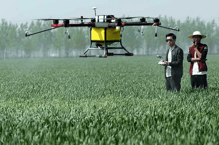
One of the most significant advancements in AgTech is the automated spraying drone. These machines utilize ultrasonic sensors and lidar (Light Detection and Ranging) to maintain a consistent height above the crop canopy, ensuring even distribution of liquids. Unlike traditional tractors, drones do not compact the soil or damage crops as they move through the field. Furthermore, drones are increasingly being used for "drone seeding"—deploying seed pods equipped with nutrients into remote or hilly terrain where traditional machinery cannot operate. This is particularly vital for reforestation projects and large-scale rice farming in Southeast Asia.
3. Multispectral Health Assessment
Beyond the visible spectrum, drones utilize multispectral sensors to measure the "greenness" of plants via the Normalized Difference Vegetation Index (NDVI). This technology detects the amount of near-infrared light reflected by leaves; healthy, chlorophyll-rich plants reflect more infrared light than stressed or diseased ones. This allows farmers to identify hidden issues—such as fungal infections or nitrogen deficiencies—days or even weeks before they become visible to the naked eye.
Market Data and Economic Impact
The economic implications of drone adoption are substantial. According to recent market research reports, the global agricultural drone market was valued at approximately $1.5 billion in 2023 and is projected to grow at a compound annual growth rate (CAGR) of over 20% through 2030. This growth is driven by the increasing need for food security as the global population nears 10 billion and the simultaneous decline in available agricultural labor.
Data from pilot programs in regions like the Midwest United States and East Asia suggest that drone integration can reduce chemical application costs by up to 30% and increase overall crop yields by 10% to 15%. In Indonesia, where smallholder farmers manage diverse and often difficult terrain, the use of drones for palm oil and rice cultivation is proving to be a game-changer for local cooperatives. By pooling resources to hire drone service providers, small-scale farmers are achieving the same levels of efficiency previously reserved for massive corporate plantations.
Regulatory Landscapes and Operational Challenges
Despite the clear benefits, the path to universal drone adoption is fraught with regulatory and technical hurdles. Governments worldwide are struggling to keep pace with the rapid evolution of UAV technology. In the United States, the Federal Aviation Administration (FAA) requires operators to obtain Part 107 certification for commercial use, while in the European Union, EASA regulations dictate strict weight and altitude limits. In many developing nations, the lack of a clear legal framework for "beyond visual line of sight" (BVLOS) operations remains a significant barrier to large-scale automation.
Technological limitations also persist. Battery life remains a primary concern; most industrial drones can only fly for 20 to 40 minutes before requiring a recharge or battery swap. This necessitates a logistical "base station" on-site, which can be difficult to manage in remote areas. Furthermore, the initial capital expenditure—ranging from $5,000 for a basic monitoring unit to over $30,000 for a fully equipped spraying system—is a deterrent for many farmers. However, the "Drones as a Service" (DaaS) model is emerging as a solution, where specialized companies provide drone flights and data analysis for a per-hectare fee, removing the need for farmers to own and maintain the hardware.
Institutional Responses and Expert Perspectives
Agricultural scientists and policymakers are increasingly vocal about the necessity of digital transformation. Dr. Elizabeth Sterling, an agronomist specializing in digital systems, notes that "the drone is the stethoscope of modern agriculture. It allows us to hear what the field is saying before the symptoms become a crisis." Many ministries of agriculture have begun incorporating drone training into their vocational programs. In countries like India and China, government subsidies for "Kisan Drones" (farmer drones) are being implemented to modernize rural economies and discourage the migration of youth to urban centers by making farming a high-tech, viable profession.
Environmental organizations have also expressed cautious optimism. The ability of drones to conduct "variable rate application" means that less nitrogen and phosphorus runoff enters local waterways, mitigating the risk of algae blooms and protecting aquatic ecosystems. The reduction in heavy machinery usage also translates to a lower carbon footprint for the farm, aligning with global net-zero targets.
Broader Implications: Toward an Autonomous Future
The long-term vision for drones in agriculture involves full integration with the "Internet of Things" (IoT). In this scenario, ground-based soil sensors would detect a drop in moisture levels and automatically trigger a drone to take off, inspect the area, and deploy a localized irrigation or nutrient boost without any human intervention. This "swarm" technology, where multiple drones work in coordination, could allow for the management of thousands of acres with minimal oversight.
Furthermore, as Artificial Intelligence (AI) becomes more sophisticated, the data collected by drones will feed into global climate models. This will help scientists understand how different crop varieties respond to shifting weather patterns, providing a vital tool in the fight against climate-induced food instability.
Conclusion: A New Horizon for Global Food Systems
The rise of drones in agriculture signifies a fundamental shift in how humanity interacts with the land. By moving the vantage point from the soil to the sky, technology has provided a way to make farming more predictable, sustainable, and profitable. While challenges regarding cost, regulation, and technical literacy remain, the trajectory is clear: the future of farming is airborne.
As these "pahlawan kecil di langit" (little heroes in the sky) become a common sight over the world’s fields, they carry with them the promise of a more efficient food system. The marriage of ancient agricultural wisdom and cutting-edge aerospace technology ensures that the sector can meet the demands of the 21st century. Ultimately, the benefit of having technology in the sky is realized in the abundance and health of the harvest on the ground, securing the livelihood of farmers and the nutrition of the global population for generations to come.