The global agricultural landscape is currently undergoing a profound technological metamorphosis, transitioning from traditional, labor-intensive practices to a high-tech era defined by precision and automation. At the forefront of this revolution is the Unmanned Aerial Vehicle (UAV), commonly known as the drone. Once reserved for military reconnaissance and high-end cinematography, drones have emerged as indispensable assets for farmers, agronomists, and land managers. By providing a "bird’s eye view" combined with sophisticated sensor data, these aerial tools are addressing some of the most critical challenges in the primary sector, including labor shortages, resource scarcity, and the escalating pressures of climate change.
The Evolution of Agricultural Aviation
The journey of drones in agriculture began in the early 2000s, primarily as a niche interest for research institutions exploring remote sensing. However, the true commercial breakthrough occurred over the last decade with the miniaturization of sensors and the improvement of battery density. Historically, aerial monitoring required expensive satellite imagery—often obscured by cloud cover—or manned aircraft rentals, which were financially out of reach for the average producer.
By 2015, the introduction of specialized agricultural drones equipped with multispectral cameras and automated flight paths democratized access to aerial data. Today, the market has matured significantly. Industry reports suggest that the global agricultural drone market, valued at approximately $1.5 billion in 2023, is projected to grow at a compound annual growth rate (CAGR) of over 20% through 2030. This growth is driven by the urgent need to increase food production by 70% to feed an estimated global population of 9.7 billion by 2050, as noted by the Food and Agriculture Organization (FAO).
Precision Monitoring and Data-Driven Decision Making
The primary utility of drones in the modern farm lies in their ability to perform high-resolution field mapping and health assessments. Unlike traditional methods, where a farmer might walk a fraction of their acreage to spot-check for pests or dehydration, drones can survey hundreds of hectares in a single afternoon.
Equipped with multispectral sensors, these drones capture data beyond the visible light spectrum. They measure the Normalized Difference Vegetation Index (NDVI), which calculates plant health by analyzing how much near-infrared light leaves reflect. Healthy, chlorophyll-rich leaves reflect more infrared light, while stressed or diseased plants absorb it. This data allows for the creation of "prescription maps," enabling farmers to apply water or fertilizer only where it is needed, rather than blanket-spraying an entire field. This targeted approach not only saves money but significantly reduces the environmental footprint of nitrogen runoff and chemical oversaturation.
Revolutionary Application: Spraying and Seeding
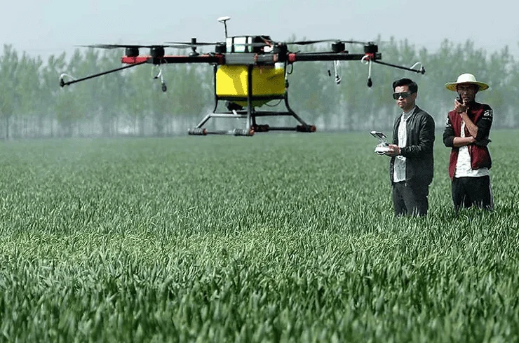
Beyond observation, the current generation of heavy-lift drones, such as the DJI Agras or XAG series, has transformed the application of inputs. These drones are equipped with sophisticated tanks and atomizing nozzles capable of delivering pesticides, herbicides, and liquid fertilizers with surgical precision.
Data from field trials indicate that drone spraying can be up to 40 times more efficient than manual labor. In regions with rugged terrain or dense canopies—such as vineyards on hillsides or fruit orchards—where tractors cannot easily maneuver, drones provide a seamless solution. Furthermore, the use of drones mitigates the health risks associated with manual chemical application, as operators can manage the flight from a safe distance, away from the drift of hazardous substances.
The technology is also being adapted for "drone-based reforestation" and seeding. In areas affected by wildfires or deforestation, drones can fire "seed pods" containing nutrients and moisture-retaining gels into the soil at high speeds, ensuring a higher germination rate in hard-to-reach locations.
Technical Infrastructure and Chronology of Operation
A typical drone operation in a modern agricultural setting follows a structured chronological workflow:
- Mission Planning: Using GPS and GIS (Geographic Information System) software, the operator defines the boundaries of the field and sets the altitude and overlap for the flight.
- Autonomous Execution: The drone executes the flight path automatically, utilizing obstacle avoidance sensors to navigate around trees or power lines.
- Data Processing: The captured images are stitched together using photogrammetry software to create a 2D orthomosaic map or a 3D model of the terrain.
- Analysis and Action: Agronomists analyze the data to identify "stress zones." If a spraying drone is utilized, the prescription map is uploaded directly to the craft, which then targets the specific coordinates identified in the analysis phase.
Economic Implications and Official Perspectives
Economically, the adoption of UAVs is a response to the rising costs of fuel and the diminishing availability of agricultural labor. In many developed nations, the average age of a farmer is now over 55, and younger generations are increasingly migrating to urban centers. Automation via drones fills this labor gap, allowing a single operator to manage tasks that previously required a team of workers.
Governmental and regulatory bodies have begun to recognize this potential. The Federal Aviation Administration (FAA) in the United States and the European Union Aviation Safety Agency (EASA) have streamlined "Part 107" and similar certifications to allow for easier commercial drone operation. In a statement regarding the integration of technology in rural areas, agriculture experts have emphasized that "the digitalization of the farm is no longer an option but a necessity for survival in a competitive global market."
However, official responses also highlight the need for data privacy and security. As drones collect vast amounts of topographical and crop data, concerns regarding who owns this information—the farmer, the drone manufacturer, or the software provider—remain a subject of intense legislative debate.
Overcoming Barriers: Costs and Connectivity
Despite the clear advantages, the path to universal adoption is not without hurdles. The initial capital expenditure remains high; a professional-grade multispectral drone and the necessary processing software can cost between $10,000 and $50,000. For smallholder farmers in developing nations, this represents a prohibitive barrier. To combat this, "Drone-as-a-Service" (DaaS) models have emerged, where third-party companies provide aerial surveys and spraying on a contract basis, making the technology accessible without the need for heavy upfront investment.
Connectivity also remains a challenge. High-resolution data processing often requires significant bandwidth or high-performance local computing, which may be unavailable in remote rural areas. Furthermore, battery life continues to limit flight times to approximately 20 to 40 minutes per charge, necessitating multiple batteries and mobile charging stations for large-scale operations.
The Broader Impact on Sustainability and Climate Change
The most significant long-term implication of drones in agriculture is their role in environmental stewardship. By optimizing the use of water and chemicals, drones contribute directly to the goals of "Climate-Smart Agriculture." They allow for a more resilient food system that can adapt to erratic weather patterns. For instance, in the event of unexpected flooding, drones can quickly assess crop damage for insurance claims and identify surviving patches to prioritize salvage operations.
Moreover, the reduction in heavy machinery usage leads to less soil compaction and lower carbon emissions from diesel-powered tractors. As the world moves toward "Net Zero" targets, the electrification of agricultural tasks via drones provides a clear pathway for reducing the carbon intensity of food production.
Conclusion: A Skyward Vision for Grounded Success
The integration of drones into the agricultural sector signifies a shift from "intuition-based" farming to "evidence-based" management. The ability to see what the human eye cannot, and to act with a level of precision that traditional machinery cannot match, has turned the drone from a futuristic novelty into a cornerstone of the modern farm.
While challenges regarding cost and regulation persist, the trajectory is clear: the future of farming is increasingly autonomous. As AI and machine learning continue to integrate with UAV hardware, we can expect drones to not only identify problems but to predict them before they occur. In the high-stakes game of global food security, the pahlawan kecil (little heroes) in the sky are proving that the best way to manage the earth is to watch it from above. The synergy between technology in the air and labor on the ground is creating a more efficient, sustainable, and productive world for generations to come.