The global agricultural landscape is currently undergoing a seismic shift as traditional farming methodologies, characterized by manual labor and heavy machinery, are being augmented or replaced by sophisticated aerial technology. Unmanned Aerial Vehicles (UAVs), commonly referred to as drones, have transitioned from niche hobbyist gadgets and military tools to essential components of the modern farmer’s toolkit. This integration represents a core pillar of "Precision Agriculture," a farming management concept based on observing, measuring, and responding to inter- and intra-field variability in crops. As the global population is projected to reach nearly 10 billion by 2050, the pressure on the agricultural sector to increase productivity while minimizing environmental impact has never been greater. Drones are emerging as a primary solution to this challenge, offering unprecedented levels of efficiency, data accuracy, and resource management.
The Historical Trajectory of Agricultural Technology
To understand the impact of drones, one must look at the chronology of agricultural innovation. For decades, the "Green Revolution" of the mid-20th century relied on mechanical automation, such as tractors and combine harvesters, alongside the intensive use of chemical fertilizers and pesticides. While these methods vastly increased yields, they often lacked precision, leading to resource waste and environmental degradation.
The late 1990s and early 2000s saw the introduction of Satellite Imagery and Global Positioning Systems (GPS) into large-scale farming. However, satellite data often suffered from low resolution, high costs, and interference from cloud cover. The real breakthrough occurred in the early 2010s with the miniaturization of sensors and the improvement of lithium-polymer battery technology. This allowed for the development of affordable, high-endurance drones capable of carrying specialized payloads. By 2015, regulatory bodies like the Federal Aviation Administration (FAA) in the United States and similar agencies globally began establishing frameworks for commercial drone use, paving the way for the current agricultural drone boom.
Core Functional Capabilities of Modern Agricultural Drones
Drones in the contemporary agricultural sector are no longer just flying cameras; they are sophisticated data collection and delivery platforms. Their utility can be categorized into three primary functional areas: high-resolution monitoring, precision application, and advanced biological analysis.
Real-Time Land and Crop Monitoring
The most immediate benefit of drone technology is the ability to conduct rapid, high-resolution aerial surveys. Traditional methods of crop scouting involve "ground truthing," where farmers or agronomists walk through fields to manually inspect plant health. On a farm spanning hundreds or thousands of hectares, this is not only time-consuming but physically impossible to perform with total coverage.
Drones equipped with high-definition RGB cameras can cover hundreds of acres in a single flight, providing real-time visual data. This allows farmers to identify "hotspots" of distress—areas where irrigation systems may have failed, where soil erosion is occurring, or where localized pest infestations are beginning. By identifying these issues early, interventions can be targeted specifically to the affected area, preventing the spread of damage and saving the rest of the crop.
Precision Spraying and Seeding
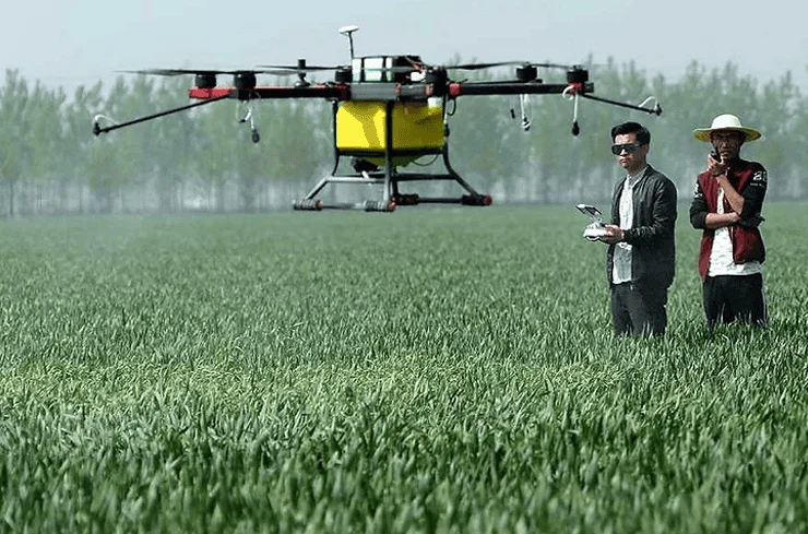
One of the most transformative applications is the use of heavy-lift drones for the application of liquid fertilizers, pesticides, and herbicides. These drones are equipped with specialized tanks and atomizing nozzles that can adjust droplet size based on the specific needs of the crop.
Unlike traditional crop-dusting planes or tractor-mounted sprayers, drones can fly at very low altitudes—often just a few meters above the canopy. This proximity significantly reduces "spray drift," a phenomenon where chemicals are carried by the wind to non-target areas, including water sources or neighboring organic farms. Data from industry trials suggests that drone spraying can be up to 40 times faster than manual backpack spraying while reducing chemical consumption by as much as 30% due to the precision of the application. Furthermore, drones can operate on steep terrain or in waterlogged fields where tractors would lose traction or cause soil compaction.
Multispectral and Hyperspectral Analysis
Beyond the visible spectrum, drones utilize multispectral sensors to measure the "health" of a plant through light reflection. Plants reflect different amounts of near-infrared (NIR) light depending on their chlorophyll content and water stress. By calculating the Normalized Difference Vegetation Index (NDVI), drones can generate "heat maps" that show exactly which plants are thriving and which are struggling long before the human eye can detect any yellowing or wilting.
This level of diagnostic detail allows for "Variable Rate Application" (VRA). Instead of applying the same amount of fertilizer across an entire field, a farmer can use drone data to program a sprayer to deliver more nutrients to struggling areas and less to healthy ones. This optimizes the "Return on Investment" (ROI) for every liter of chemical used and protects the soil from over-saturation.
Supporting Data and Market Analysis
The economic impetus for adopting drone technology is supported by robust market data. According to recent reports by Grand View Research and Fortune Business Insights, the global agricultural drone market was valued at approximately $1.5 billion in 2023 and is projected to grow at a Compound Annual Growth Rate (CAGR) of over 20% through 2030.
This growth is driven by several factors:
- Labor Shortages: In many developed nations, the aging farming population and a lack of interest in manual agricultural labor among younger generations have created a vacuum that technology must fill.
- Cost Reduction: While the initial investment in a professional-grade drone system can range from $10,000 to $50,000, the operational savings in chemicals, water, and fuel typically result in a "break-even" point within two to three growing seasons.
- Climate Volatility: As weather patterns become more unpredictable, the ability to rapidly assess storm damage or drought impact is vital for insurance claims and emergency replanting strategies.
Perspectives from Industry Stakeholders and Regulators
The integration of drones has drawn reactions from various sectors of society. Agricultural ministries in countries like India, China, and Brazil have actively subsidized drone technology for smallholder farmers, viewing it as a tool for national food security. In China, for instance, the government has promoted the use of "swarming" drones—multiple units working in tandem—to manage vast rice paddies, significantly boosting national output.
Environmental organizations have generally offered a positive response, citing the reduction in chemical runoff as a major victory for biodiversity and water quality. However, regulatory bodies remain cautious. The primary concern for aviation authorities is the integration of drones into "shared airspace." As drones become larger and fly higher, the risk of mid-air collisions with manned aircraft increases. This has led to strict licensing requirements for drone pilots, necessitating specialized training and certification in many jurisdictions.
Challenges to Widespread Adoption
Despite the clear advantages, the path to universal drone adoption in agriculture is not without obstacles. The "digital divide" remains a significant barrier; farmers in developing regions often lack the high-speed internet required to upload and process the massive amounts of data generated by multispectral sensors.
Furthermore, battery life remains a technical bottleneck. Most current industrial drones have a flight time of 20 to 40 minutes before requiring a battery swap or recharge. While this is sufficient for small to medium-sized farms, it necessitates a complex logistical setup for massive commercial operations, involving portable charging stations and multiple battery sets.
Data management is another hurdle. A single flight can produce gigabytes of raw imagery. For this data to be useful, it must be processed through specialized software to create actionable maps. Many farmers find the transition from "tilling the soil" to "analyzing data clouds" to be a steep learning curve, leading to a rise in "Agriculture-as-a-Service" (AaaS) companies that provide drone pilots and data analysts on a contract basis.
Broader Implications and the Future of the "Smart Farm"
The rise of drones is a precursor to the fully autonomous "Smart Farm" of the future. As Artificial Intelligence (AI) continues to evolve, the next generation of agricultural drones will not require manual piloting. Instead, they will be housed in "drone-in-a-box" docking stations located around the farm. These units will automatically deploy at scheduled intervals, conduct their surveys, return to charge, and send an alert to the farmer’s smartphone only when a problem is detected.
The implications for environmental sustainability are profound. By moving toward a model of "per-plant" management rather than "per-field" management, the agricultural industry can significantly reduce its carbon footprint. Reduced tractor usage means lower diesel emissions, and more efficient water use helps preserve critical aquifers.
In conclusion, the presence of drones in the skies above our farmlands represents more than just a technological novelty; it is a fundamental shift in how humanity interacts with the earth. By bridging the gap between high-level data and ground-level action, drones are enabling a more resilient, efficient, and sustainable food system. As the technology continues to mature and costs continue to decline, the sight of a drone hovering over a field will become as common and as essential as the sight of a tractor has been for the last century. The future of agriculture is no longer tethered solely to the ground; it is increasingly being navigated from the air.