The global agricultural sector is currently undergoing a structural transformation characterized by the integration of high-tech solutions into traditional cultivation practices. For decades, the image of farming was inextricably linked to manual labor and heavy ground machinery like tractors and combine harvesters. However, a new protagonist has emerged in the skies above the world’s croplands: the agricultural drone. Formally known as Unmanned Aerial Vehicles (UAVs), these devices are no longer relegated to the realms of military surveillance or recreational photography. Today, they serve as sophisticated data-gathering and operational tools that are fundamentally altering the efficiency, sustainability, and profitability of modern farming.
The Evolution of Agricultural Technology: A Brief Chronology
The journey of drones into the agricultural mainstream has been a multi-decade progression. In the late 20th century, the concept of "precision agriculture" began to take root, utilizing Global Positioning Systems (GPS) to help farmers map their fields and manage resources more effectively. By the early 2000s, satellite imagery became the gold standard for monitoring large-scale crop health. However, satellites were often hindered by cloud cover and limited resolution.
The pivotal shift occurred around 2010 with the miniaturization of sensors and the improvement of lithium-polymer battery technology. This allowed for the development of multi-rotor drones that could hover and navigate complex terrains with ease. By 2015, companies like DJI and XAG began producing specialized agricultural platforms equipped with spraying tanks and multispectral cameras. Between 2018 and 2024, the adoption rate of these technologies skyrocketed, driven by the need for more efficient resource management in the face of rising labor costs and the intensifying impacts of climate change.
Core Functional Capabilities of Modern Agricultural UAVs
The contemporary agricultural drone is a multi-functional powerhouse. Its utility is generally categorized into three primary domains: aerial mapping and monitoring, precision application, and physiological health analysis.
1. Real-Time Field Mapping and Surveillance
One of the most immediate benefits of UAV integration is the ability to conduct rapid, high-resolution surveys of vast tracts of land. Traditionally, a farmer would need to "scout" their fields on foot or via a ground vehicle—a process that is time-consuming, physically demanding, and prone to human error. A drone can cover 50 to 100 hectares in a single flight, providing a bird’s-eye view that reveals patterns invisible from the ground.
These maps allow for the identification of "problem zones," such as irrigation leaks, drainage issues, or localized pest infestations. By identifying these issues early, farmers can intervene before a small problem becomes a farm-wide disaster, effectively safeguarding their yields.
2. Precision Spraying and Seeding
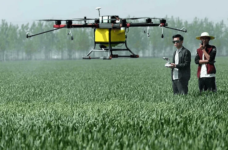
Drone technology has revolutionized the application of liquid inputs, including fertilizers, herbicides, and pesticides. Unlike traditional tractor-mounted sprayers, which can compact the soil and damage crops as they pass through the rows, drones fly above the canopy. They utilize "centrifugal atomization" and ultra-low volume (ULV) spraying techniques, which break the liquid into micro-droplets that adhere better to the leaves.
The precision of these systems is governed by RTK (Real-Time Kinematic) GPS, which offers centimeter-level accuracy. This ensures that chemicals are applied only where they are needed, significantly reducing the total volume of chemicals used and minimizing the risk of runoff into local water sources.
3. Advanced Physiological Analysis via Multispectral Sensing
Beyond visible light cameras, advanced drones carry multispectral and thermal sensors. These sensors measure the "Normalized Difference Vegetation Index" (NDVI), which calculates the amount of chlorophyll in plants by analyzing how they reflect near-infrared light. This data allows agronomists to detect "stress" in plants—whether from dehydration, nutrient deficiency, or disease—weeks before the symptoms become visible to the human eye.
Supporting Data: The Economic and Operational Impact
The shift toward drone-assisted farming is backed by compelling data regarding efficiency and ROI (Return on Investment). According to market research reports, the global agricultural drone market was valued at approximately $1.5 billion in 2023 and is projected to reach over $5 billion by 2030, growing at a CAGR (Compound Annual Growth Rate) of nearly 20%.
In terms of operational efficiency, the statistics are even more striking:
- Speed: A single drone can spray crops up to 40 to 60 times faster than manual labor using backpack sprayers.
- Water Conservation: Drone spraying typically uses 90% less water than traditional methods because the concentrated mist is more effective at covering the plant surface.
- Chemical Reduction: Precision application can lead to a 30% to 50% reduction in pesticide and fertilizer usage, which directly lowers the overhead costs for the farmer.
- Safety: By automating the spraying process, human exposure to potentially toxic chemicals is reduced to near zero.
Industry Perspectives and Stakeholder Reactions
The integration of drones has been met with a mix of enthusiasm and cautious pragmatism from industry stakeholders. Agricultural tech developers emphasize the "democratization of data," arguing that drones provide small-to-mid-sized farmers with the same analytical power previously reserved for massive corporate plantations.
"We are seeing a paradigm shift where the farmer is becoming a data scientist," says an industry analyst specializing in ag-tech. "The drone is the sensor that feeds the algorithm, allowing for a level of micro-management that was physically impossible a decade ago."
However, some farming cooperatives have expressed concerns regarding the "digital divide." The initial capital expenditure for a high-end agricultural drone system—which includes the aircraft, batteries, charging stations, and specialized software—can range from $10,000 to $30,000. For many smallholder farmers, this remains a significant barrier to entry. To address this, a new service economy has emerged, where "drone-as-a-service" (DaaS) providers are hired by farmers to perform seasonal mapping and spraying, removing the need for individual ownership.
Navigating Challenges: Regulation and Skill Requirements
Despite the clear advantages, the path to universal drone adoption is not without hurdles. The two most prominent challenges are regulatory frameworks and the technical skill gap.
Regulatory bodies, such as the Federal Aviation Administration (FAA) in the United States or the Civil Aviation Authority (CAA) in various European and Asian nations, have strict rules regarding UAV operations. In many jurisdictions, operating a heavy agricultural drone (which can weigh over 25kg when fully loaded) requires a commercial pilot license and specific certifications for chemical application.
Furthermore, there is a steep learning curve. Operating a drone is only half the battle; the real value lies in interpreting the data. Farmers must learn to navigate GIS (Geographic Information System) software and translate NDVI maps into actionable "prescription maps" for their equipment. Educational institutions and agricultural extension offices are currently ramping up training programs to ensure the next generation of farmers is "drone-literate."
Broader Implications: Climate Resilience and Food Security
The implications of drone technology extend far beyond the individual farm; they are a critical component of global food security. As the world’s population approaches 10 billion by 2050, the agricultural sector must produce 70% more food on roughly the same amount of arable land.
Drones provide a mechanism for "climate-smart" agriculture. In regions suffering from unpredictable rainfall, drones can monitor soil moisture levels with high precision, allowing for targeted irrigation that preserves scarce water resources. During outbreaks of invasive pests, such as the desert locust swarms seen in East Africa and parts of Asia, drones have been deployed to track and treat swarms in areas that are inaccessible to ground vehicles.
By maximizing the output of every acre while minimizing the environmental footprint, drones are helping to create a more resilient food system that can withstand the volatility of the 21st century.
Conclusion: A New Horizon for Global Agriculture
The rise of drones in the agricultural world represents a synthesis of ancient practice and futuristic innovation. The transition from the "muscle-powered" farming of the past to the "data-driven" farming of the present is not merely a matter of convenience; it is a necessary evolution for a planet with finite resources and a growing appetite.
While challenges regarding cost and regulation persist, the trajectory is clear. As hardware becomes more affordable and artificial intelligence (AI) begins to automate the analysis of aerial data, the drone will become as common a sight in the barn as the tractor or the plow. The future of agriculture is being written in the skies, proving that the most effective way to care for the earth is to gain a better perspective from above. By bridging the gap between technological potential and practical application, drones are ensuring that the agricultural industry remains sustainable, efficient, and capable of feeding the world for generations to come.