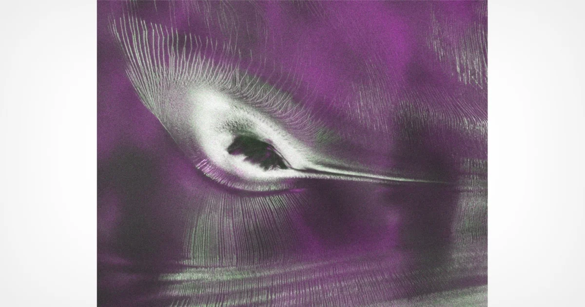
A NASA satellite, part of the groundbreaking NISAR mission, has delivered a remarkably intricate image of the Antarctic landscape, featuring a unique geological formation that bears a striking resemblance to a hummingbird. This extraordinary visual, far from being an artistic rendering, is a real-time snapshot of the Earth’s dynamic surface, captured with unprecedented detail by advanced radar technology. The image not only captivates with its aesthetic appeal but also provides invaluable data for glaciologists and climate scientists worldwide, offering a new window into the complex processes shaping our planet’s polar regions.
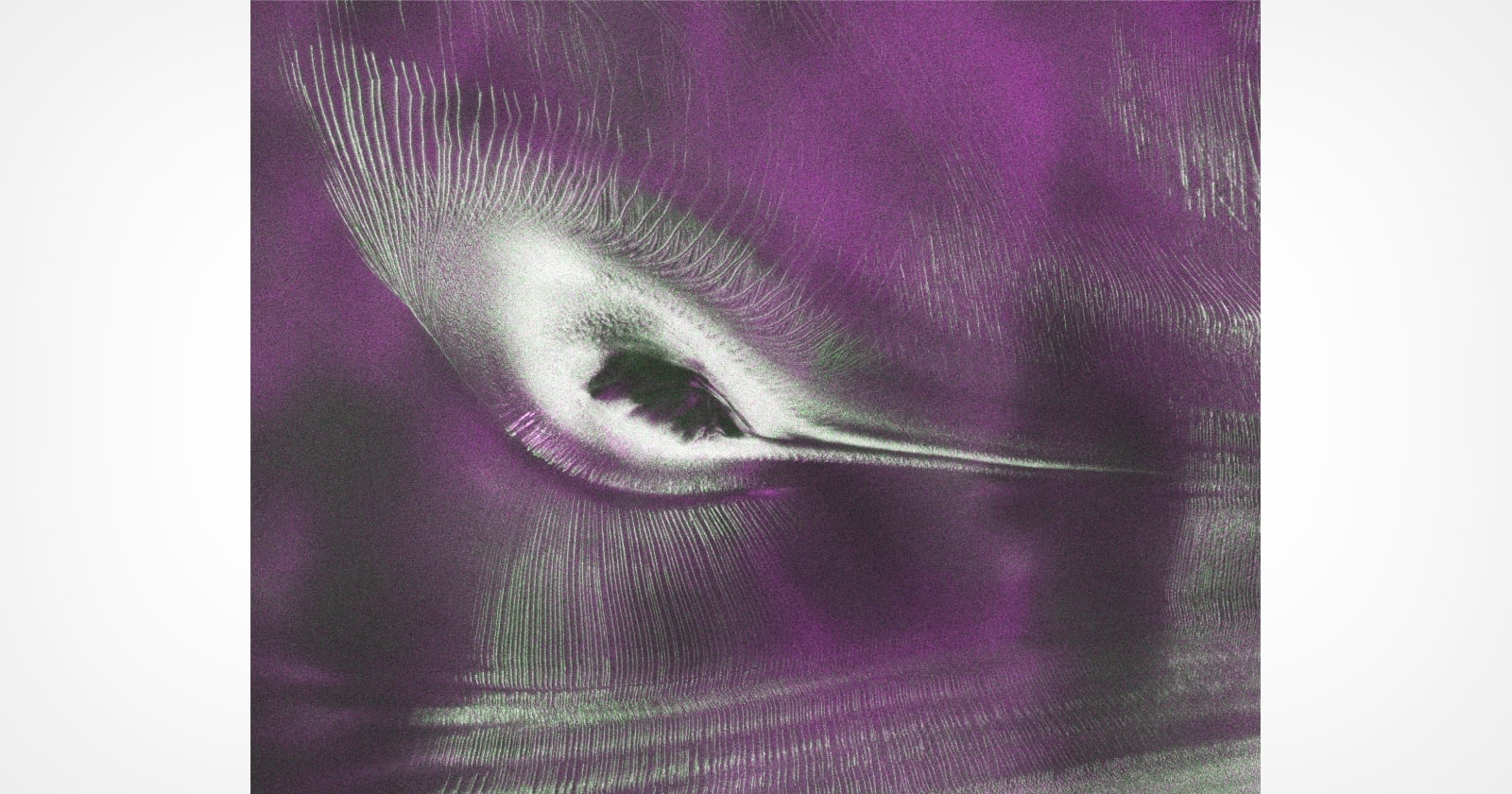
The compelling satellite image, publicly released on a Tuesday, depicts a fractured, barren expanse of East Antarctica. At its heart lies Nunatak Zaterjavshijsja, a prominent mountaintop that emerges from the vast sheet of ice, resembling the head and body of a small, purple-toned bird. Extending northeast from this peak, a stream of ice flows towards the Southern Ocean, forming what appears to be the bird’s elongated tail. Perhaps the most dramatic feature, contributing to the "hummingbird" moniker, are the radiating green lines spreading from the mountain. These are deep cracks, known as crevasses, which form as the colossal glacier navigates around the obstruction of Nunatak Zaterjavshijsja, causing immense stress within the ice. NISAR scientists, recognizing the unique configuration, affectionately nicknamed the formation "the hummingbird."
The Genesis of the Image: NISAR’s L-Band Radar and Advanced Earth Observation
This striking visual was not captured by a conventional optical camera but by the sophisticated L-band radar system aboard the NISAR (NASA-ISRO Synthetic Aperture Radar) satellite. This joint mission between the U.S. National Aeronautics and Space Administration (NASA) and the Indian Space Research Organisation (ISRO) represents a monumental leap in Earth observation capabilities. The data for the "hummingbird" image was specifically collected in August 2025, during a critical phase of system testing for the satellite’s powerful instruments.
Unlike optical sensors that rely on visible light and can be obscured by clouds, darkness, or ice, NISAR’s radar instruments transmit their own signals and measure the reflections. The L-band radar, in particular, operates at a longer wavelength (approximately 15-30 centimeters), allowing it to penetrate through dense vegetation, snow, and even several meters of ice. This unique capability is what enabled NISAR to reveal the subsurface structure and intricate fracturing of the Antarctic ice sheet with such clarity, providing insights that are simply impossible with traditional optical imagery. The purple and green coloration in the image is a result of data processing, where different radar signal characteristics are assigned specific colors to highlight variations in surface texture, composition, and movement.
Seongsu Jeong, a signal analysis engineer at NASA’s Jet Propulsion Laboratory (JPL) in Southern California, who was instrumental in producing the image, articulated the dual significance of the data. "First, it’s a beautiful image, with rich details of features that provide insights to how the glacier is moving. Then, because radar can often see through snow and deep into the ice, NISAR can observe fundamentally different properties of Antarctic ice than can be seen in optical imagery," Jeong stated. He added, "With NISAR we’re seeing what’s hidden beneath the surface." This statement underscores the mission’s core strength: its ability to peer beneath the superficial layers of Earth’s surface, offering an unprecedented understanding of its dynamic processes.
NISAR: A Collaborative Endeavor for Global Climate Monitoring
The NISAR mission itself is a testament to international scientific collaboration and a critical tool in the global effort to understand climate change and its impacts. Launched with the primary objective of observing and measuring changes in Earth’s land and ice surfaces in unprecedented detail, NISAR is designed to provide consistent, high-resolution data every 12 days. This systematic monitoring is crucial for detecting subtle shifts in ecosystems, ice sheets, and fault lines that could indicate significant environmental changes or potential natural hazards.
The collaboration between NASA and ISRO on NISAR is particularly noteworthy. NASA is responsible for the L-band synthetic aperture radar, while ISRO contributed the S-band radar and the spacecraft bus. This dual-band radar system allows scientists to observe a wider range of phenomena. The S-band radar (operating at shorter wavelengths, around 8-15 centimeters) is particularly useful for monitoring vegetation and soil moisture, complementing the L-band’s deep penetration capabilities. The satellite’s orbit, a near-polar sun-synchronous path, ensures comprehensive global coverage, allowing for repeated observations of virtually every point on Earth’s land and ice surfaces.
The mission’s scientific objectives are expansive, encompassing:
- Ice Sheet Dynamics: Monitoring the flow and thickness of ice sheets and glaciers, crucial for understanding sea-level rise.
- Ecosystem Disturbances: Tracking changes in forests, wetlands, and agricultural areas, including deforestation, agricultural productivity, and natural disasters like floods and wildfires.
- Solid Earth Processes: Measuring subtle shifts in Earth’s crust caused by earthquakes, volcanoes, and landslides, aiding in hazard assessment and disaster response.
- Cryosphere Evolution: Observing permafrost thaw, changes in seasonal snow cover, and variations in sea ice extent.
The successful capture of the "hummingbird" image during initial system testing signifies that NISAR’s instruments are performing as expected, laying the groundwork for a treasure trove of scientific data in the years to come.
Understanding Glacial Mechanics and Crevasse Formation in Antarctica
The "hummingbird" image provides a vivid illustration of fundamental glaciological principles. Nunatak Zaterjavshijsja, a rock outcrop that stands proud above the surrounding ice, acts as a significant impediment to the inexorable flow of the East Antarctic ice sheet. Glaciers, though appearing static, are in a constant state of slow motion, driven by gravity. As the massive body of ice encounters the unyielding rock of the nunatak, it must deform and flow around it. This process creates immense shear stress within the ice.
The feature resembling the bird’s tail is, in fact, the glacier itself, extending towards the ocean. The "feathers" radiating from the peak are the deep crevasses. These fractures are not random occurrences but a direct consequence of the stress distribution around the nunatak. As the ice flows past the obstruction, different parts of the glacier move at varying speeds. The ice directly in front of and immediately behind the nunatak experiences compression and tension, respectively, while the ice flowing past its sides experiences significant shear. This differential movement and stress cause the brittle ice to fracture, forming the characteristic deep, linear cracks known as crevasses. These crevasses can be hundreds of meters long, tens of meters wide, and penetrate deep into the glacier, posing significant hazards to ground expeditions.
The green lines in the processed radar image highlight these crevasses with remarkable clarity, indicating the deep fracturing of the surrounding surfaces. The ability of NISAR’s L-band radar to penetrate snow cover means it can detect crevasses that might be hidden beneath a superficial layer of fresh snow, making it an invaluable tool for both scientific study and operational safety in polar regions. Understanding the formation and propagation of these crevasses is critical for glaciologists to model ice flow dynamics accurately and predict the stability of ice sheets.
Broader Implications for Climate Science, Sea-Level Rise, and Hazard Monitoring
The data from NISAR, exemplified by the "hummingbird" image, has profound implications across multiple scientific disciplines. For climate science, the mission provides an unprecedented capability to monitor changes in Earth’s ice sheets and glaciers, which are direct indicators of global warming. Antarctica’s ice sheet, the largest single mass of ice on Earth, holds enough water to raise global sea levels by approximately 58 meters if it were all to melt. Even small changes in its stability and flow rate can have significant consequences for coastal communities worldwide. NISAR’s precise measurements of ice velocity and thickness changes will greatly improve the accuracy of sea-level rise projections, allowing for better adaptation strategies.
Beyond ice, NISAR’s ability to measure subtle changes in land surface deformation offers critical insights into solid Earth processes. It can detect ground deformation caused by earthquakes, volcanic unrest, and landslides with millimeter-level precision. This data can be used to map active fault lines, understand the mechanics of seismic events, and forecast potential volcanic eruptions or landslide hazards, thereby enhancing early warning systems and disaster preparedness efforts. For example, detecting pre-seismic crustal deformation or inflation around volcanoes can provide crucial lead time for evacuations.
Furthermore, NISAR’s observations of vegetation cover and biomass will aid in understanding carbon cycling and ecosystem health. By tracking changes in forest extent, agricultural productivity, and wetland dynamics, scientists can assess the impact of human activities and climate change on terrestrial ecosystems. The L-band radar is particularly effective at penetrating forest canopies, allowing for accurate measurements of forest structure and biomass, which are vital for estimating carbon sequestration potential.
Operational Milestones and Future Prospects
The successful data collection in August 2025 and the subsequent release of images like the "hummingbird" mark significant operational milestones for the NISAR mission. Following its launch, the satellite underwent an extensive commissioning phase, during which all its instruments and systems were meticulously tested and calibrated. The quality of the "hummingbird" image confirms that the L-band radar is functioning optimally, delivering the high-resolution, detailed imagery that scientists eagerly anticipated.
The initial test data has already demonstrated NISAR’s capability to produce highly detailed radar imagery that reveals features of Earth’s surface, both visible and hidden. As the mission transitions into its full operational phase, it will begin its systematic global data collection, building a comprehensive, consistent record of Earth’s dynamic surface. Scientists expect NISAR to revolutionize our understanding of numerous Earth processes, from the slow creep of glaciers to the rapid shifts of tectonic plates. The mission is planned for at least three years, with the potential for extension, promising a continuous stream of invaluable data for the scientific community for years to come.
The insights gained from NISAR will not only advance fundamental scientific understanding but also provide practical applications for resource management, hazard mitigation, and environmental protection. The data will be freely available to researchers and the public, fostering global collaboration and innovation in Earth science.
The Ongoing Quest to Map Our Planet
The "hummingbird" image from Antarctica serves as a powerful reminder of the hidden complexities and stunning beauty of our planet, even in its most remote and seemingly barren regions. It encapsulates the essence of scientific discovery: turning raw data into compelling visuals that spark curiosity and deepen understanding. More importantly, it highlights the critical role of advanced satellite missions like NISAR in our ongoing quest to map, monitor, and comprehend the intricate workings of Earth’s systems. In an era defined by rapid environmental change, tools that allow us to "see what’s hidden beneath the surface" are not just scientific marvels, but essential instruments for safeguarding our planet’s future. The NISAR mission, with its eye on the Earth, promises to be a cornerstone of environmental observation for decades to come, providing the foundational knowledge necessary to address some of the most pressing challenges facing humanity.