The agricultural landscape is undergoing its most significant transformation since the Industrial Revolution, as traditional farming methods converge with cutting-edge aerospace technology to meet the demands of a growing global population. Once reserved for military reconnaissance and high-end cinematography, Unmanned Aerial Vehicles (UAVs), commonly known as drones, have emerged as indispensable tools for modern farmers seeking to optimize yields and reduce environmental impact. This shift toward "Precision Agriculture" represents a move away from the generalized, resource-heavy practices of the past toward a data-driven approach where every square meter of a field is monitored, analyzed, and treated with surgical precision.
The Integration of UAVs into Modern Agronomy
For decades, the standard for large-scale farming involved heavy machinery and significant manual labor. Farmers relied on visual inspections and broad-spectrum applications of fertilizers and pesticides, often resulting in waste and environmental runoff. However, the introduction of agricultural drones has provided a "bird’s-eye view" that was previously only accessible via expensive satellite imagery or manned aircraft. Unlike satellites, which can be obscured by cloud cover and offer lower resolution, drones operate beneath the clouds, providing high-definition, real-time data that allows for immediate intervention.
The deployment of drones in agriculture is not merely a trend but a response to the urgent need for efficiency. According to recent market analysis reports, the global agricultural drone market is projected to reach over $5 billion by 2030, growing at a compound annual growth rate (CAGR) of approximately 20%. This growth is fueled by the increasing necessity to automate labor-intensive tasks and the rising global demand for food, which the Food and Agriculture Organization (FAO) of the United Nations predicts must increase by 70% by 2050 to sustain the world’s population.
A Chronology of Agricultural Evolution
The journey toward drone integration began in the late 20th century with the advent of Global Positioning Systems (GPS) for tractors. This allowed for more accurate planting and harvesting. By the early 2010s, hobbyist drones began to pique the interest of tech-savvy farmers. However, it was the development of specialized sensors—multispectral, thermal, and LiDAR—that truly transitioned drones from toys to industrial tools.
In 2015, the regulatory environment began to shift, particularly in the United States with the Federal Aviation Administration (FAA) granting exemptions for agricultural drone use. This sparked a wave of innovation, leading to the creation of heavy-lift drones capable of carrying liquid payloads. By 2020, drone technology had become sophisticated enough to allow for autonomous flight paths, where a pilot simply defines a boundary on a tablet and the drone executes a pre-programmed mission, returning to base only to swap batteries or refill tanks.
Precision Monitoring and the Science of Multispectral Imaging
One of the most profound impacts of drones is their ability to monitor crop health through multispectral imaging. While the human eye sees only the visible light spectrum, specialized drone cameras can detect "invisible" wavelengths, specifically near-infrared (NIR) light.
Healthy plants reflect a high amount of NIR light because of their chlorophyll content. By using the Normalized Difference Vegetation Index (NDVI), drones can generate "heat maps" of a field. These maps reveal areas of stress—caused by pests, nutrient deficiencies, or lack of water—long before the damage is visible to a farmer walking the rows. This early detection capability allows for "spot treatments," where a farmer only applies chemicals to the affected area rather than an entire 100-acre field. Industry data suggests that this targeted approach can reduce chemical usage by up to 30%, significantly lowering input costs and protecting local ecosystems from chemical runoff.
Revolutionizing Application: Spraying and Seeding from the Air
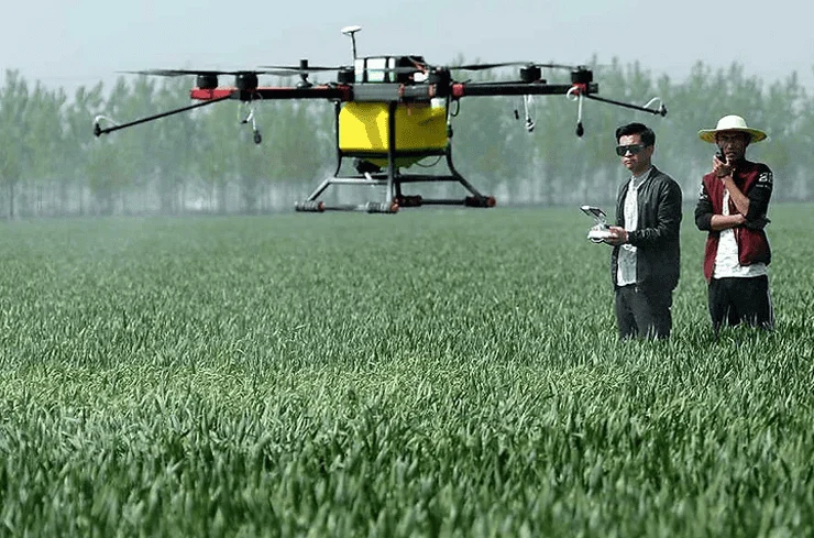
Beyond monitoring, drones are physically altering how inputs are applied to the land. Traditional crop dusting via manned planes is dangerous and imprecise, while ground-based tractors can compact the soil and damage crops. Agricultural spraying drones, equipped with advanced nozzles and flow meters, can fly centimeters above the crop canopy, ensuring that the spray reaches its target without drifting into neighboring fields.
In regions with difficult terrain, such as the terraced rice paddies of Southeast Asia or the steep vineyards of Europe, drones have become a lifeline. These areas are often inaccessible to heavy machinery. A single drone can spray a hectare of land in less than ten minutes—a task that would take a human worker several hours of grueling labor. Furthermore, the use of drones removes the operator from direct contact with hazardous chemicals, representing a major advancement in occupational safety for the agricultural sector.
Recent innovations have also expanded drone capabilities to include "drone-assisted seeding." By utilizing compressed air, drones can fire seed pods containing nutrients and moisture-retaining gels directly into the soil. This method is being utilized not only in commercial farming but also in massive reforestation projects designed to combat climate change.
The Economic Case for Drone Adoption
While the initial investment in drone technology can range from $1,000 for basic monitoring units to over $30,000 for advanced spraying systems, the return on investment (ROI) is becoming increasingly clear. Large-scale operations report that the data provided by drones can increase crop yields by 5% to 15% through better management of water and fertilizers.
For smaller landholders, the "Drone-as-a-Service" (DaaS) model has emerged. Service providers travel from farm to farm, offering aerial mapping or spraying services on a per-acre basis. This democratizes the technology, allowing farmers who cannot afford the upfront costs to still benefit from high-tech insights. This service model has seen particularly rapid growth in India and China, where government subsidies are encouraging the adoption of AgTech to modernize rural economies.
Regulatory Hurdles and Technical Challenges
Despite the clear benefits, the path to universal drone adoption is not without obstacles. Regulatory frameworks vary significantly by country. In many jurisdictions, pilots are required to maintain a visual line of sight (VLOS) with the drone, which limits the efficiency of monitoring massive estates. Furthermore, the legal requirements for "swarming"—operating multiple drones by a single pilot—remain stringent in many Western nations, though some countries are beginning to ease these restrictions to allow for more autonomous operations.
Technical limitations also persist. Battery life remains a primary constraint, with most industrial drones offering flight times of only 20 to 40 minutes before requiring a recharge. While hydrogen-powered drones and hybrid engines are in development to address this, they are not yet widely available at a commercial price point. Additionally, the massive amounts of data generated by 4K and multispectral cameras require robust internet infrastructure for processing—a luxury that many remote farming communities currently lack.
Expert Perspectives and Global Responses
Agricultural experts and policymakers are increasingly vocal about the role of UAVs. Dr. Robert Blair, a pioneer in precision agriculture, has frequently noted that "drones are not replacing the farmer; they are giving the farmer better eyes and better data to make informed decisions."
In response to the technology’s potential, various government bodies have launched initiatives to integrate drones into national agricultural strategies. For instance, the European Union’s "Green Deal" emphasizes the reduction of pesticides, a goal that many officials believe is only achievable through the precision application enabled by drone technology. Similarly, the United States Department of Agriculture (USDA) has invested millions in research grants to explore how drone data can be integrated into climate-smart farming practices.
The Broader Impact: Sustainability and Climate Resilience
The implications of drone technology extend far beyond the balance sheets of individual farms. By optimizing resource use, drones play a critical role in environmental sustainability. The reduction in fuel consumption—replacing a heavy diesel tractor with an electric drone—lowers the carbon footprint of food production. Moreover, the ability to monitor soil moisture levels with thermal sensors allows for more efficient irrigation, a vital capability as water scarcity becomes a more pressing issue globally.
As climate change leads to more unpredictable weather patterns, the speed of drone deployment becomes a strategic advantage. After a major storm or flood, drones can quickly assess damage across thousands of acres, allowing farmers to file insurance claims faster and make quick decisions about whether to replant.
Conclusion: A High-Tech Future for the Oldest Industry
The rise of the drone in agriculture signifies a shift toward a more intelligent, responsive, and sustainable food system. By bridging the gap between the soil and the sky, these aerial tools are providing the insights necessary to feed a crowded planet while preserving the environment.
While challenges regarding cost, regulation, and technical training remain, the trajectory is clear. The future of farming will be defined by the integration of artificial intelligence, autonomous robotics, and aerial data. As the technology matures, the sight of a drone hovering over a field will become as common as the sight of a tractor, marking a new era where the oldest industry on earth embraces the most advanced technology of the modern age. The "pioneer in the sky" is no longer a novelty; it is a fundamental pillar of the next agricultural revolution.