The landscape of modern farming is undergoing a profound transformation, moving away from the traditional reliance on heavy machinery and manual labor toward a data-driven, aerial-centric approach known as precision agriculture. For decades, the agricultural sector was defined by the rhythmic operation of tractors and the physical presence of farmers scouting their fields on foot. However, the emergence of Unmanned Aerial Vehicles (UAVs), commonly known as drones, has introduced a new dimension to land management. These sophisticated machines are no longer relegated to the realms of military surveillance or hobbyist photography; they have become essential tools for the 21st-century farmer, offering a bird’s-eye view that provides critical insights into crop health, soil conditions, and resource allocation.
The Historical Transition from Manual Labor to Aerial Intelligence
To understand the impact of drones in the current agricultural climate, it is necessary to examine the chronology of aerial technology in farming. The concept of managing crops from above is not entirely new. As early as the 1920s, the first aerial crop-dusting experiments were conducted in the United States using biplanes to combat boll weevil infestations in cotton fields. While effective, manned aerial application was expensive, dangerous, and lacked precision.
The shift toward unmanned systems began in earnest during the 1980s in Japan. Faced with an aging farming population and rugged terrain unsuitable for large tractors, the Japanese government encouraged the development of remote-controlled helicopters. The Yamaha RMAX, launched in the early 1990s, became the gold standard for aerial spraying in rice paddies. However, these early systems were bulky, difficult to pilot, and lacked the autonomous capabilities seen today.
The real revolution occurred in the 2010s with the convergence of GPS technology, miniaturized sensors, and advanced battery life. This era saw the transition from simple remote-controlled aircraft to fully autonomous UAVs capable of executing complex flight paths with centimeter-level accuracy. Today, the integration of Artificial Intelligence (AI) and Machine Learning (ML) has turned agricultural drones into flying supercomputers, capable of analyzing vast amounts of environmental data in real-time.
Core Functionalities and Technical Capabilities
The utility of drones in agriculture is multifaceted, addressing various stages of the crop lifecycle. Unlike traditional methods that often treat an entire field as a single unit, drone technology allows for "site-specific" management.
1. Advanced Multispectral Imaging and Crop Health Analysis
One of the most significant contributions of drones is the use of multispectral and hyperspectral sensors. These cameras capture light waves that are invisible to the human eye, specifically the near-infrared (NIR) spectrum. By calculating the Normalized Difference Vegetation Index (NDVI), drones can identify "plant stress" long before it becomes visible to a farmer on the ground.
When plants are healthy, they reflect high amounts of NIR light. Conversely, stressed plants—whether due to water deficiency, nutrient imbalance, or pest infestation—absorb more of this light. By generating high-resolution NDVI maps, drones allow farmers to pinpoint specific zones in a field that require intervention. This prevents the unnecessary application of fertilizers across healthy areas, thereby reducing costs and environmental runoff.
2. Precision Spraying and Variable Rate Technology (VRT)
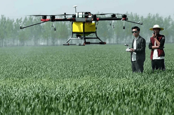
Modern agricultural drones, such as the DJI Agras or XAG series, are equipped with sophisticated liquid tanks and atomizing nozzles. These drones can carry payloads ranging from 10 to 50 liters and are designed to fly just meters above the crop canopy.
The primary advantage of drone spraying is precision. Using Variable Rate Technology (VRT), drones can adjust the flow rate of pesticides or fertilizers based on the specific needs of different field sections. According to industry data, drone-based spraying can be up to 40 times faster than manual backpack spraying and significantly more efficient than traditional tractor-mounted sprayers, which often struggle with soil compaction and crop damage during late-season applications.
3. Irrigation Management and Thermal Mapping
Water scarcity is an escalating concern for global agriculture. Drones equipped with thermal sensors can detect the temperature of the soil and the plant canopy. Areas with higher temperatures often indicate "evapotranspiration" issues or clogged irrigation lines. By identifying these "hot spots," farmers can optimize their irrigation schedules, ensuring that water is delivered exactly where it is needed, which is crucial for sustainable water management in drought-prone regions.
Supporting Data and Economic Impact
The global agricultural drone market is currently experiencing exponential growth. Market research reports from firms like Goldman Sachs and Fortune Business Insights suggest that the agricultural sector will soon become the second-largest user of drones, trailing only the construction industry. The global market value for agricultural drones was estimated at approximately $1.2 billion in 2020 and is projected to reach over $5 billion by 2030, growing at a Compound Annual Growth Rate (CAGR) of over 18%.
The return on investment (ROI) for farmers is increasingly evident. For large-scale operations, the ability to reduce chemical usage by 30% and water consumption by 20% leads to significant annual savings. In a study conducted on corn and soybean farms in the Midwestern United States, the use of drone-derived data for nitrogen application resulted in an average yield increase of 5% to 10% due to more accurate nutrient delivery.
Industry Perspectives and Official Responses
International organizations and government bodies have begun to recognize the strategic importance of this technology. The Food and Agriculture Organization of the United Nations (FAO) has highlighted drones as a key component in achieving global food security, especially in the face of a growing global population expected to reach 9.7 billion by 2050.
"The integration of digital tools like UAVs is not a luxury; it is a necessity for the future of food production," stated an agronomist from a leading European research institute. "We are seeing a shift where the farmer’s most important tool is no longer the plow, but the data tablet."
However, regulatory bodies like the Federal Aviation Administration (FAA) in the U.S. and the European Union Aviation Safety Agency (EASA) face the challenge of balancing innovation with safety. Regulations regarding Beyond Visual Line of Sight (BVLOS) flights and the operation of heavy-payload spray drones are still evolving. In many jurisdictions, farmers are required to obtain specific pilot certifications and chemical application licenses, which remains a barrier to entry for some smallholder operations.
Challenges to Widespread Adoption
Despite the clear benefits, the "digital divide" remains a significant hurdle. The initial capital investment for a high-end multispectral drone and the accompanying analytical software can range from $5,000 to over $30,000. For small-scale farmers in developing economies, this cost is often prohibitive.
Furthermore, there is a steep learning curve associated with data processing. Capturing images is only half the battle; interpreting the data requires specialized software and, often, the assistance of a certified agronomist. To combat this, a "Drone-as-a-Service" (DaaS) model has emerged. In this model, third-party service providers fly the drones and provide farmers with actionable reports, allowing the growers to benefit from the technology without the burden of equipment maintenance or pilot training.
Data privacy also remains a point of contention. As drones collect high-resolution imagery of private land, concerns regarding who owns that data and how it might be used by insurance companies or government agencies have led to calls for clearer data governance frameworks within the agricultural tech industry.
Broader Implications: Climate Change and Labor Shortages
The rise of drones is also a response to two of the greatest threats to modern agriculture: climate change and labor shortages. As weather patterns become increasingly unpredictable, the ability to rapidly assess storm damage or drought impact is vital for insurance claims and recovery efforts. Drones allow for "disaster scouting" that is safer and faster than sending human crews into flooded or damaged fields.
Simultaneously, many agricultural regions are facing a crisis of labor. The physical toll of farming has led to a migration of the younger generation toward urban centers, leaving an aging workforce behind. Drones fill this gap by automating tasks that were previously labor-intensive. One drone operator can monitor hundreds of acres in a single morning, a task that would have required a large team of scouts just a decade ago.
Conclusion: The Future of the High-Tech Harvest
The integration of drones into the world of agriculture represents more than just a trend; it is a fundamental shift in how humanity interacts with the land. By bridging the gap between high-level satellite imagery and ground-level observation, drones provide a level of granularity that was previously impossible.
As battery technology improves and AI algorithms become more adept at predicting crop yields and identifying diseases, the "smart farm" will become the global standard. The future of agriculture lies in the synergy between the soil and the sky. While the roots of farming will always remain firmly planted in the earth, the success of the harvest will increasingly depend on the silent, efficient sentinels patrolling the heavens above. Through the continued adoption of drone technology, the agricultural sector is poised to become more efficient, more sustainable, and more resilient in an ever-changing world.