The Lençóis Maranhenses National Park, a sprawling 600-square-mile natural wonder in northeastern Brazil, has become the subject of intense photographic exploration, particularly through the lens of aerial perspectives. This unique ecosystem, characterized by its vast expanses of undulating white sand dunes interspersed with seasonal rain-fed lagoons, offers a breathtaking landscape that has captivated photographers and earned it recognition as a recently declared World Heritage Site. The park’s dynamic topography, a mosaic of interlacing river systems, crystal-clear lagoons, and extensive dune fields, presents an ever-changing canvas that challenges conventional photographic approaches.
Situated in the state of Maranhão, the Lençóis Maranhenses is a testament to the raw beauty and powerful forces of nature. Its geography is defined by a stark contrast: arid, sweeping dunes that can reach heights of up to 40 meters, and during the rainy season (typically from January to June), these dunes become transformed by thousands of ephemeral freshwater lagoons. These lagoons, varying in color from deep blues to vibrant greens, create a visually stunning spectacle against the pristine white sand. The park’s eastern border is marked by over 40 miles of coastline, fringed with small fishing villages that gently slope into the vastness of the Atlantic Ocean.
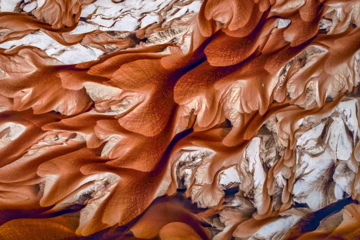
The interior of the park is a complex network of winding, tannin-colored river systems that snake their way through the dunes towards the sea. These rivers, often appearing inky black due to the leached tannins from decaying vegetation, carve intricate paths, further accentuating the sculpted landscape. To the west, the desert-like environment gradually transitions into cerrado (Brazilian savanna) and then into forested areas before giving way to agricultural lands, showcasing a remarkable ecological gradient.
The Evolution of Aerial Documentation
Historically, capturing the grandeur of such expansive and remote landscapes often necessitated the use of cramped, open-cockpit aircraft like ultralights or Cessnas. These methods, while effective, presented limitations in terms of accessibility, maneuverability, and the ability to achieve intimate yet comprehensive shots. However, the advent of drone technology and Unmanned Aerial Vehicles (UAVs) has revolutionized aerial photography, opening up unprecedented creative possibilities.
Modern drones allow for a far more nuanced approach to capturing these vast vistas. Photographers can now maintain a delicate balance, flying at altitudes low enough to discern the intricate details of the terrain – the delicate ripples of sand, the subtle textures of the dune crests, and the precise colors of the lagoons – while still encompassing the full, awe-inspiring scale of the landscape. This technological leap has enabled a deeper exploration of the park’s visual narrative, allowing for a more intimate dialogue between the photographer and the environment.
A Living, Breathing Landscape
The dynamic nature of Lençóis Maranhenses is a key element of its photographic appeal. The constant interplay of wind and sand creates a perpetually shifting tableau. Each gust reshapes the dunes, toppling delicate sandy peaks and stirring the glassy surfaces of the lagoons. The wind acts as a natural sculptor, continuously redefining the park’s contours. This ephemeral quality means that no two visits, and indeed no two moments, will ever yield the exact same visual.
The coloration of the lagoons adds another layer of visual complexity. The tannins, leached from the abundant decaying vegetation found in the surrounding cerrado and forests, impart a spectrum of rich hues to the water. These range from deep reds and browns to vibrant rust tones, creating striking reflections and refractions across the sandy canvas. The Black River, a significant waterway that winds its way through the coastal lowlands, exemplifies this phenomenon. Its dark, tannin-rich waters contrast dramatically with the white sand, appearing like a giant, inky serpent snaking towards its confluence with the Parnaíba River in the northeast. The sheer visual impact of these colors and forms can be almost overwhelming, prompting a continuous effort to find the perfect angle and altitude to capture the essence of the scene.
A Long History of Artistic Inspiration
The human impulse to interpret and replicate the beauty of the natural world is ancient, stretching back tens of thousands of years. Evidence of this profound connection can be found in prehistoric cave paintings, such as those at Chauvet Cave in France, which depict animals with remarkable detail and artistry, dating back to the Aurignacian period approximately 30,000 years ago. Throughout history, artists across diverse cultures and eras, from the Upper Paleolithic to the Renaissance and beyond, have dedicated their lives to the meticulous study of nature. Their efforts have been focused on capturing the intricate details and grand designs of the natural world with unparalleled fidelity.
Even with the advanced capabilities of modern digital cameras and sophisticated aerial drones, the challenge of fully translating nature’s artistry into a static image remains. The sheer scale of our planet, from the vastness of its geological formations to the microscopic complexity of a cell’s nucleus, presents a profound challenge to representational art. The photographer’s endeavor, while utilizing cutting-edge technology, is a continuation of this age-old quest to document and communicate the profound beauty of the natural world.

Ecological Significance and Conservation Efforts
Lençóis Maranhenses National Park was established in 1981 and encompasses approximately 1,500 square kilometers (580 square miles). Its designation as a UNESCO World Heritage Site in 2014 underscores its global importance as a unique natural landscape. The park’s delicate ecosystem is vulnerable to environmental changes, and ongoing conservation efforts are crucial to its preservation.
The park’s hydrological cycle is intrinsically linked to the regional climate. The seasonal rainfall dictates the presence and fullness of the lagoons, which are vital habitats for various species of fish, amphibians, and invertebrates. Many of these species have adapted to the temporary nature of the lagoons, with some fish eggs being able to survive in the dry sand for months until the rains return. The white sand itself, composed primarily of quartz crystals, reflects sunlight, contributing to the unique microclimate of the park and providing a striking visual contrast.
Socio-Economic Context
The Lençóis Maranhenses region is also home to traditional communities, many of whom rely on fishing and subsistence agriculture. The park’s status as a protected area and a UNESCO World Heritage Site presents both opportunities and challenges for these communities. Ecotourism has become an increasingly important economic driver, offering alternative livelihoods while raising awareness about the importance of conservation.
However, the increasing popularity of the park also necessitates careful management to mitigate the potential negative impacts of tourism. Sustainable tourism practices, community involvement, and effective park management are essential to ensure that the economic benefits of tourism do not come at the expense of the park’s ecological integrity or the well-being of its local inhabitants. The balance between conservation and sustainable development is a continuous and critical consideration for the future of Lençóis Maranhenses.
The Photographer’s Perspective: A Quest for Representation
For photographers like the author of the original piece, the experience of documenting Lençóis Maranhenses is not merely about capturing an image; it is a profound engagement with the sublime. The vastness of the dunes, the ephemeral beauty of the lagoons, and the intricate patterns formed by wind and water evoke a sense of wonder and humility. The decision to utilize drone technology was driven by a desire to transcend conventional viewpoints and to explore the landscape from a perspective that more closely mirrors the grand, overarching designs of nature itself.
The process of flying a drone over such a landscape is described as an artistic sojourn, a departure from the usual focus on close-up wildlife portraits. It is an opportunity to immerse oneself in the "heart of wild habitats" on a grand scale. The ability to adjust altitude and angle in real-time allows for an intuitive response to the unfolding visual narrative. The photographer’s commentary highlights the struggle to translate the full depth and grandeur of such a place into a photographic print, echoing the sentiments of artists throughout history who have strived to capture the ineffable beauty of the natural world.
Broader Implications and Future Outlook
The photographic documentation of Lençóis Maranhenses National Park, particularly through advanced aerial techniques, serves multiple purposes. Firstly, it provides invaluable visual records of a dynamic and sensitive ecosystem, aiding in scientific research and monitoring. Secondly, it acts as a powerful tool for raising public awareness and appreciation for the importance of preserving such unique natural landscapes. Thirdly, it contributes to the growing body of work that explores the intersection of technology, art, and nature.
The ongoing exploration of places like Lençóis Maranhenses through photography, especially from novel perspectives, underscores the enduring human fascination with the natural world. It reinforces the idea that even with technological advancements, the profound artistry of nature remains a source of inspiration and a testament to the delicate balance of our planet. The privilege of attempting to capture this beauty, as the photographer eloquently states, is a lifelong pursuit that connects us to the very essence of life on Earth. The future of Lençóis Maranhenses hinges on continued dedication to conservation, responsible tourism, and a deep respect for the natural processes that have sculpted this extraordinary corner of the globe.