The global agricultural landscape is currently undergoing a profound transformation as traditional farming methodologies converge with cutting-edge aerospace technology. Historically, the image of agriculture was one of manual labor, heavy machinery, and ground-based observations. However, the emergence of Unmanned Aerial Vehicles (UAVs), commonly known as drones, has introduced a new dimension to the industry. These sophisticated aerial platforms are no longer relegated to military or recreational use; they have become indispensable tools for modern farmers seeking to optimize yields, reduce costs, and implement sustainable practices. As the world faces the dual challenges of a growing population and a changing climate, the integration of drones into the agricultural sector represents a critical leap toward high-precision "smart farming."
The Technological Evolution of Agricultural UAVs
The adoption of drones in agriculture has followed a rapid chronological progression over the last two decades. In the early 2000s, aerial surveillance of crops was primarily the domain of expensive satellite imagery or manned aircraft, both of which lacked the resolution and flexibility required for daily farm management. By 2010, the proliferation of consumer drone technology allowed early adopters to capture basic RGB (Red, Green, Blue) images of their fields, providing a "bird’s-eye view" that helped identify obvious issues like flooding or massive crop failure.
The true turning point occurred between 2015 and 2020 with the miniaturization of specialized sensors. The introduction of multispectral and thermal cameras allowed drones to "see" beyond the human eye, detecting changes in plant health before physical symptoms appeared. Today, the industry has entered a phase of high-capacity automation. Modern agricultural drones are equipped with artificial intelligence (AI), obstacle avoidance systems, and heavy-lift capabilities for autonomous liquid and granular application. This evolution marks a shift from simple observation to active, data-driven intervention.
Core Functional Applications in the Field
The utility of drones in contemporary agriculture is multifaceted, addressing various stages of the crop lifecycle. These applications can be categorized into three primary functions: real-time monitoring, precision spraying, and advanced health analytics.
Real-Time Monitoring and Mapping
Drones offer an unparalleled ability to conduct rapid aerial surveys of vast territories. A drone can scout a 100-hectare farm in less than 20 minutes—a task that would take a human scout an entire day of walking. Through photogrammetry, these drones create high-resolution 2D maps and 3D models of the terrain. This allows farmers to monitor irrigation systems, identify drainage issues, and assess crop damage following extreme weather events with extreme precision.
Precision Spraying and Seeding
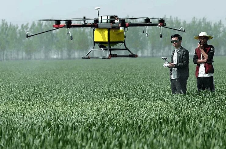
One of the most significant advancements in the sector is the development of "spray drones." These heavy-duty UAVs are equipped with tanks and specialized nozzles designed to apply fertilizers, herbicides, and pesticides. Unlike traditional tractors, drones do not compact the soil or damage crops during the application process. Furthermore, they can operate in hilly or muddy terrain where ground vehicles cannot maneuver.
Recent data suggests that drone-based spraying can be up to 40 times faster than manual spraying while reducing chemical waste by 30% to 50%. By using "spot-spraying" techniques, drones only apply chemicals to the specific plants that need them, rather than blanket-spraying an entire field. This not only saves money but also significantly reduces the environmental footprint of the farm.
Advanced Crop Health Analysis
By utilizing multispectral sensors, drones measure the Normalized Difference Vegetation Index (NDVI). This index tracks the amount of near-infrared light reflected by plants; healthy, chlorophyll-rich leaves reflect more infrared light than stressed or dying ones. This data provides a "heat map" of crop vigor, allowing farmers to identify nutrient deficiencies, pest infestations, or water stress weeks before they become visible to the naked eye.
Supporting Data and Market Analysis
The economic impact of this technology is substantial. According to a 2023 industry report by Grand View Research, the global agricultural drone market was valued at approximately USD 3.5 billion and is projected to grow at a compound annual growth rate (CAGR) of over 20% through 2030. This growth is driven by the increasing demand for food security and the rising cost of manual labor.
In a comparative study conducted in Southeast Asia, rice farmers utilizing drone technology for fertilization reported a 10% to 15% increase in yield. The precision of the application ensured that each plant received the optimal amount of nutrients, leading to more uniform growth. Additionally, the reduction in labor hours allowed these farmers to manage larger plots of land without a proportional increase in overhead costs.
Addressing Challenges and Barriers to Adoption
Despite the clear benefits, the transition to drone-integrated farming is not without obstacles. The primary barrier for small-scale farmers remains the initial capital investment. High-end agricultural drones, including the necessary software for data analysis and specialized sensors, can cost between $10,000 and $50,000. While the return on investment (ROI) is often realized within two to three growing seasons, the upfront cost can be prohibitive.
Furthermore, the regulatory landscape remains complex. Aviation authorities, such as the Federal Aviation Administration (FAA) in the United States or the European Union Aviation Safety Agency (EASA), have strict requirements for commercial drone pilots. Obtaining the necessary certifications and adhering to "Beyond Visual Line of Sight" (BVLOS) regulations requires significant time and training.
Technical challenges also persist. Battery life currently limits most agricultural drones to 15–30 minutes of flight time per charge, necessitating multiple batteries and mobile charging stations for large-scale operations. Additionally, the sheer volume of data generated by multispectral mapping requires robust internet connectivity and high-performance computing, which may be lacking in remote rural areas.
Industry Responses and Global Implications
Agricultural experts and government bodies are increasingly recognizing drones as a solution to labor shortages. In Japan, where the average age of a farmer is over 67, the government has actively subsidized drone technology to allow an aging workforce to maintain productivity. Similarly, in the United States and Brazil, large-scale industrial farms are integrating "drone swarms"—where one operator manages multiple UAVs simultaneously—to maximize efficiency.
Environmental advocacy groups have also responded positively to the trend. By enabling precision agriculture, drones facilitate a reduction in the total volume of nitrogen-based fertilizers used. This mitigates the risk of chemical runoff into local water supplies, a major cause of aquatic "dead zones." The ability of drones to assist in "carbon farming" by monitoring soil health and reforestation efforts further aligns the technology with global climate goals.
Strategic Implications for the Future of Food Security
The implications of drone technology extend far beyond the individual farm; they are a cornerstone of future global food security. As the global population is expected to reach 9.7 billion by 2050, the Food and Agriculture Organization (FAO) of the United Nations estimates that food production must increase by 70%. Achieving this without further destroying natural habitats requires a drastic increase in "per-acre" productivity.
Drones provide the data granularity needed to move from "average-based" farming to "plant-based" farming. Instead of treating a 50-acre field as a single unit, farmers can treat each square meter according to its specific needs. This level of management is the only viable path toward sustainable intensification.
Moreover, the integration of AI and machine learning will soon allow drones to operate with even higher levels of autonomy. Future systems will likely involve "docking stations" located in fields, where drones can automatically launch, scan, spray, and return to recharge without any human intervention. These autonomous ecosystems will bridge the gap between data collection and physical action, creating a truly responsive agricultural environment.
Conclusion: A New Horizon for the Agricultural Sector
Drone technology has successfully transitioned from a high-tech novelty to a fundamental pillar of modern agriculture. By providing a comprehensive view from the sky, these devices have empowered farmers with insights that were previously unattainable. While challenges regarding cost, regulation, and technical infrastructure remain, the trajectory of the industry is clear: the future of farming is digital, aerial, and data-driven.
As we look toward the coming decade, the synergy between the farmer on the ground and the drone in the air will be the defining characteristic of successful agriculture. The "pioneer in the sky" is no longer a pilot or a hobbyist; it is the modern farmer, using every tool available to ensure that the earth remains productive and sustainable for generations to come. The sky is no longer the limit for agriculture; it is the starting point for a more efficient and food-secure world.