The landscape of modern agriculture is undergoing a profound transformation, moving away from the traditional reliance on heavy ground machinery and manual labor toward a sophisticated, data-driven approach. At the forefront of this evolution is the integration of Unmanned Aerial Vehicles (UAVs), commonly known as drones. Once primarily associated with military applications or hobbyist photography, drones have emerged as essential tools for farmers seeking to optimize yields, reduce costs, and implement sustainable practices in an increasingly volatile climate. This technological shift represents a move toward "precision agriculture," where every square meter of a farm is managed with surgical accuracy.
The Evolution of Aerial Technology in Farming
The journey of drones in the agricultural sector began in the early 2010s when advancements in GPS technology, battery life, and sensor miniaturization allowed for the creation of affordable, reliable UAVs. Initially, these devices were used for simple aerial surveys, providing farmers with a "bird’s-eye view" of their properties that was previously only available through expensive satellite imagery or manned aircraft flights. However, as the software ecosystems surrounding these devices matured, the utility of drones expanded from simple observation to complex intervention.
Today, the integration of artificial intelligence (AI) and machine learning has allowed drone platforms to do more than just record video. They now serve as flying diagnostic laboratories. The chronology of this adoption has moved from early experimentation by tech-savvy "early adopters" to a mainstream industrial standard. In regions like Southeast Asia, North America, and Europe, agricultural drones are now integrated into the standard seasonal workflow, used for everything from soil analysis before planting to yield estimation just before harvest.
Core Functionalities and Operational Efficiency
The primary value proposition of drones in agriculture lies in their ability to perform tasks with greater speed and precision than traditional methods. Industry data suggests that a single drone can scout a 100-acre field in less than 20 minutes, a task that would take a human scout several hours of walking through difficult terrain.
Real-Time Monitoring and Mapping
Drones equipped with high-resolution RGB cameras provide real-time visual data that allows farmers to identify drainage issues, soil erosion, and localized crop stress. By generating orthomosaic maps—large, detailed images created by stitching together hundreds of smaller photos—farmers can track the progress of their crops over time. This temporal data is crucial for understanding how different varieties of seeds perform under specific environmental conditions.
Precision Spraying and Seeding
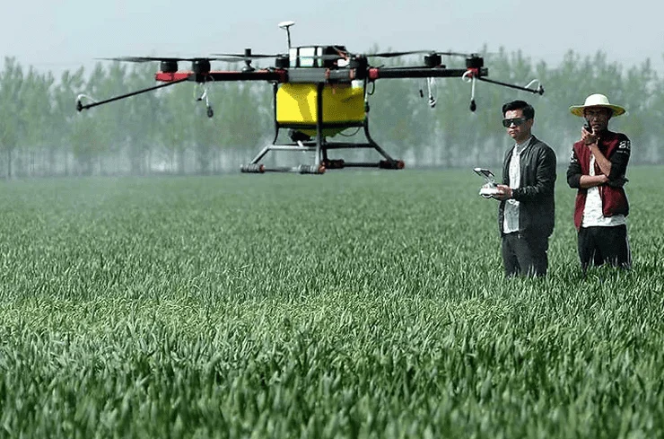
One of the most significant advancements is the development of heavy-lift drones designed for the application of liquid fertilizers and pesticides. Unlike traditional crop dusters (manned planes) or tractor-mounted sprayers, drones can fly just a few meters above the crop canopy. This proximity, combined with downward airflow from the rotors (propwash), ensures that the chemicals penetrate deep into the foliage and do not drift into neighboring fields or water sources.
Furthermore, "variable rate application" (VRA) technology allows drones to spray only the areas that need treatment. If a drone’s sensors detect a localized pest outbreak in the northwest corner of a field, it can be programmed to treat only that specific area, reducing chemical usage by up to 30-50% compared to blanket spraying.
Multispectral and Thermal Sensing
Beyond the visible spectrum, drones utilize multispectral sensors to measure the Normalized Difference Vegetation Index (NDVI). This index calculates the "greenness" or photosynthetic activity of plants. By analyzing the amount of near-infrared light reflected by leaves, drones can detect plant stress weeks before it becomes visible to the human eye. This early warning system allows for interventions—such as targeted irrigation or nitrogen application—that can save a crop from failure. Thermal sensors are also used to monitor irrigation systems, identifying leaks or clogged nozzles by detecting temperature variances on the ground.
Market Data and Economic Implications
The economic impact of drone technology in the agricultural sector is substantial. According to recent market research reports, the global agricultural drone market was valued at approximately $1.5 billion in 2023 and is projected to grow at a compound annual growth rate (CAGR) of over 20% through 2030. This growth is driven by the increasing need for food production to support a growing global population and the rising cost of manual labor in rural areas.
In terms of Return on Investment (ROI), large-scale farming operations report that the cost of a professional-grade drone system can often be recouped within a single growing season. The savings are found in three main areas:
- Reduced Input Costs: Less water, fertilizer, and pesticide are used due to precise application.
- Labor Savings: Drones automate the scouting and spraying processes, allowing fewer workers to manage larger areas.
- Increased Yield: Early detection of pests and diseases prevents crop loss, leading to higher volumes of marketable produce.
Addressing Challenges: Cost, Regulation, and Technical Barriers
Despite the clear benefits, the path to universal adoption is not without obstacles. The initial capital expenditure remains a significant barrier for smallholder farmers. A fully equipped agricultural drone system, including the aircraft, specialized sensors, and data processing software, can cost anywhere from $10,000 to $50,000.
To mitigate this, a new "Drone-as-a-Service" (DaaS) business model has emerged. In this model, third-party service providers visit farms and perform drone operations for a fee, allowing small-scale farmers to benefit from high-end technology without the upfront investment.
Regulatory frameworks also play a critical role. In many jurisdictions, operating a drone for commercial purposes requires a pilot’s license and specific certifications for chemical application. Navigating these legal requirements can be daunting for traditional farmers. However, government agencies, such as the FAA in the United States and EASA in Europe, are working to streamline these processes as the safety and efficacy of agricultural drones become more apparent.
Training and digital literacy represent the final hurdle. Operating a drone is only half the battle; the real value lies in interpreting the data. This has led to an increase in educational programs and agricultural cooperatives focused on teaching farmers how to use GIS (Geographic Information Systems) and cloud-based analytics platforms.
Official Responses and Global Perspectives
International organizations have voiced strong support for the integration of drones in farming. The Food and Agriculture Organization (FAO) of the United Nations has highlighted drone technology as a key component in achieving the Sustainable Development Goal of "Zero Hunger." In a recent report, the FAO noted that drones are particularly effective in disaster-prone areas, where they can quickly assess crop damage after floods or droughts, facilitating faster insurance claims and government aid.
Agricultural ministries in countries like India and China have also launched subsidy programs to encourage drone adoption. In India, the "Kisan Drone" initiative aims to promote the use of drones for crop assessment and spraying, viewing it as a way to modernize the rural economy and attract younger, tech-savvy generations back to the agricultural sector.
Broader Implications: Sustainability and Climate Resilience
The implications of drone technology extend far beyond the balance sheets of individual farms. As the world faces the challenges of climate change, drones offer a way to make agriculture more resilient. By optimizing resource use, drones contribute to a reduction in the carbon footprint of farming operations. Tractors, which are heavy and run on diesel, contribute to soil compaction and greenhouse gas emissions. Drones, being electric and lightweight, offer a much cleaner alternative for many tasks.
Moreover, drones are proving invaluable in the fight against desertification and deforestation. Some specialized drones are now being used for "aerial reforestation," capable of firing seed pods into the ground with high precision, allowing for the rapid planting of trees in areas that are inaccessible to humans.
Conclusion: A New Era for the Global Food Supply
The integration of drones into the world of agriculture is a testament to the power of technological convergence. By combining aerospace engineering, sensor technology, and data analytics, the agricultural sector is finding new ways to meet the demands of a changing world. While challenges regarding cost and regulation persist, the trajectory is clear: the future of farming is elevated.
As these "sentinels of the sky" continue to evolve, they will provide the data necessary to feed a planet of 8 billion people while minimizing the environmental impact of food production. The drone is no longer a futuristic novelty; it is a fundamental pillar of the modern farm, ensuring that while the technology stays in the sky, the benefits are firmly rooted in the earth. The era of the "connected farm" has arrived, and it is being managed from the air.