The global agricultural landscape is currently undergoing a profound transformation as traditional farming practices converge with cutting-edge aerospace engineering, specifically through the integration of Unmanned Aerial Vehicles (UAVs), commonly known as drones. Once reserved for military reconnaissance or high-end cinematography, drones have emerged as a cornerstone of "Precision Agriculture," a farming management concept based on observing, measuring, and responding to inter- and intra-field variability in crops. This technological shift marks the end of the era where agricultural labor was defined solely by manual toil and heavy ground machinery, ushering in an age of data-driven efficiency that promises to bolster food security in an increasingly volatile climate.
The Shift Toward Precision Agriculture
For decades, the standard approach to farming involved uniform treatment across entire fields. Whether applying water, fertilizer, or pesticides, farmers generally treated every acre the same, leading to significant waste and environmental runoff. The introduction of drone technology has disrupted this "one-size-fits-all" methodology. By providing a "bird’s-eye view" coupled with advanced sensor data, drones allow farmers to identify specific areas of a field that require attention, leaving healthy areas untouched. This level of granularity not only reduces the cost of inputs but also minimizes the chemical footprint of industrial farming.
The adoption of drones in agriculture is not merely a trend but a response to pressing global challenges. With the global population projected to reach nearly 10 billion by 2050, the Food and Agriculture Organization (FAO) estimates that agricultural production must increase by 70% to meet demand. Drones offer a scalable solution to maximize yields while optimizing the use of limited natural resources.
Core Functions and Technological Capabilities
The utility of drones in the agricultural sector is multifaceted, spanning the entire crop lifecycle from soil analysis to post-harvest assessments. These functions are powered by a suite of sophisticated hardware and software integrations.
1. Advanced Aerial Surveillance and Real-Time Monitoring
Drones equipped with high-resolution RGB cameras provide farmers with frequent, low-cost aerial imagery. Unlike satellite imagery, which can be obscured by cloud cover or suffer from low resolution, drones fly below the clouds and can capture details down to the individual leaf level. This real-time monitoring allows for the rapid detection of "stressors"—factors such as irrigation leaks, nitrogen deficiencies, or early-stage pest infestations—that would be invisible to a scout walking the perimeter of a massive plantation.
2. Multispectral and Hyperspectral Imaging
Perhaps the most significant leap in agricultural drone technology is the use of multispectral sensors. These cameras capture light waves beyond the visible spectrum, specifically near-infrared (NIR) light. By calculating the Normalized Difference Vegetation Index (NDVI), drones can assess the photosynthetic activity of plants. Healthy plants reflect more NIR light, while stressed plants absorb more. This data enables farmers to create "prescription maps," identifying exactly which zones need more nutrients or water days or even weeks before the human eye could detect a problem.
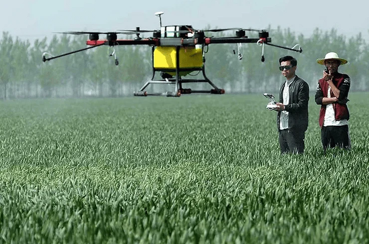
3. Precision Spraying and Variable Rate Application (VRA)
Agricultural spraying drones, such as those in the DJI Agras or XAG series, are equipped with ultrasonic sensors, GPS, and complex pumping systems. These units can fly autonomously over pre-defined paths, delivering fertilizers, herbicides, or pesticides with surgical precision.
The benefits are twofold: first, the drones use "Variable Rate Application" to adjust the flow of liquid based on the needs of the specific patch of soil beneath them. Second, they eliminate the need for heavy tractors to enter the fields, which prevents soil compaction and allows for treatment even when the ground is too muddy for ground vehicles. Industry data suggests that drone spraying can be up to 40 times more efficient than manual labor while reducing chemical consumption by up to 30%.
A Chronology of Drone Integration in Farming
The journey of drones from experimental tools to essential farm equipment has followed a clear chronological progression over the last two decades.
- 2000–2010: The Experimental Phase. Early use of UAVs in agriculture was largely confined to university research and large-scale Japanese rice paddies, where Yamaha’s RMAX helicopter-style drones were used for seeding and spraying.
- 2010–2015: The Hardware Explosion. The rise of consumer drone companies and the miniaturization of GPS and sensors made flight more accessible. Startups began experimenting with mounting GoPro cameras on quadcopters to survey fields.
- 2016–2020: Software and Regulation. Regulatory bodies like the FAA (Federal Aviation Administration) in the United States and EASA in Europe began establishing frameworks for commercial drone use. Simultaneously, software platforms like DroneDeploy and Pix4D emerged, allowing farmers to turn raw aerial photos into actionable 3D maps and data sets.
- 2021–Present: The Era of Autonomy and AI. Modern agricultural drones are now largely autonomous. They utilize Artificial Intelligence (AI) to differentiate between crops and weeds, allowing for "spot spraying" where only the weed is targeted. Swarm technology, where one operator manages multiple drones simultaneously, is also becoming a reality.
Economic Impact and Market Data
The financial implications of drone adoption are substantial. According to market research reports, the global agricultural drone market was valued at approximately USD 1.5 billion in 2023 and is projected to grow at a Compound Annual Growth Rate (CAGR) of over 20% through 2030.
For the individual farmer, the Return on Investment (ROI) is often realized through cost savings in inputs. A study conducted on corn and soybean farms indicated that drone-assisted nitrogen management could save farmers between $5 and $15 per acre. In large-scale operations spanning thousands of acres, these savings translate into tens of thousands of dollars in annual profit. Furthermore, the reduction in water usage—a critical factor in drought-prone regions—positions drones as a vital tool for economic sustainability.
Overcoming Barriers to Entry
Despite the clear advantages, the path to universal adoption is not without hurdles. The primary challenge remains the initial capital expenditure. High-end multispectral drones and spraying units can cost anywhere from $10,000 to $50,000, excluding the cost of data processing software and pilot certification.
To mitigate this, a new business model known as "Drone-as-a-Service" (DaaS) has emerged. Third-party providers now offer drone flyovers and spraying services to small-to-medium-sized farms, allowing growers to reap the benefits of the technology without the burden of ownership or technical maintenance.
Additionally, the "digital divide" remains a concern. Utilizing drone data requires a certain level of technical literacy and access to high-speed internet for cloud-based data processing. In response, many agricultural cooperatives and government agencies have begun hosting training workshops to equip traditional farmers with the skills necessary to operate these systems and interpret the resulting data.
Stakeholder Perspectives and Regulatory Landscape
The rapid rise of drones has prompted reactions from various sectors. Environmental advocacy groups generally support the technology due to its ability to reduce chemical runoff into local water tables. Conversely, privacy advocates have raised concerns regarding aerial surveillance, leading to the development of strict "data ownership" laws ensuring that the information collected by a drone belongs to the landowner, not the drone manufacturer.
Governmental bodies are also refining the "rules of the sky." Regulations now often require operators to hold a remote pilot certificate and adhere to strict weight and altitude limits. In many jurisdictions, "Beyond Visual Line of Sight" (BVLOS) operations are currently restricted, though the industry is lobbying for changes that would allow drones to cover even larger territories autonomously.
Future Implications: Sustainability and Climate Resilience
Looking forward, the role of drones will likely expand into climate change mitigation. As weather patterns become more unpredictable, drones can provide the rapid response needed to assess crop damage after storms or manage irrigation during heatwaves. Researchers are also exploring the use of drones for "reforestation" and "automated seeding," where drones fire seed pods into the soil to quickly replant areas affected by wildfires or deforestation.
The integration of drones with the "Internet of Things" (IoT) will create a fully connected farm ecosystem. In this future, ground-based soil sensors will trigger a drone launch automatically when moisture levels drop, and the drone will, in turn, signal the irrigation system to activate only in the dry zones.
Conclusion: A New Era for the Agrarian Sector
The emergence of drones in agriculture represents a pivotal moment in human history where technology serves as a bridge between industrial productivity and environmental stewardship. By moving the farmer’s perspective from the ground to the sky, drones provide the clarity needed to make precise, informed, and sustainable decisions.
While challenges regarding cost and regulation persist, the trajectory is clear: the future of farming is digital, autonomous, and aerial. As these "pahlawan kecil di langit" (small heroes in the sky) continue to evolve, they will remain indispensable allies in the quest to feed a growing world while preserving the health of the planet. The marriage of the soil and the sky is no longer a futuristic concept—it is the current reality of the modern farm.